
Home of K-fab

|
|
|
|
WELCOME TO ARIZONA
The R&R tourist guide for our beloved state
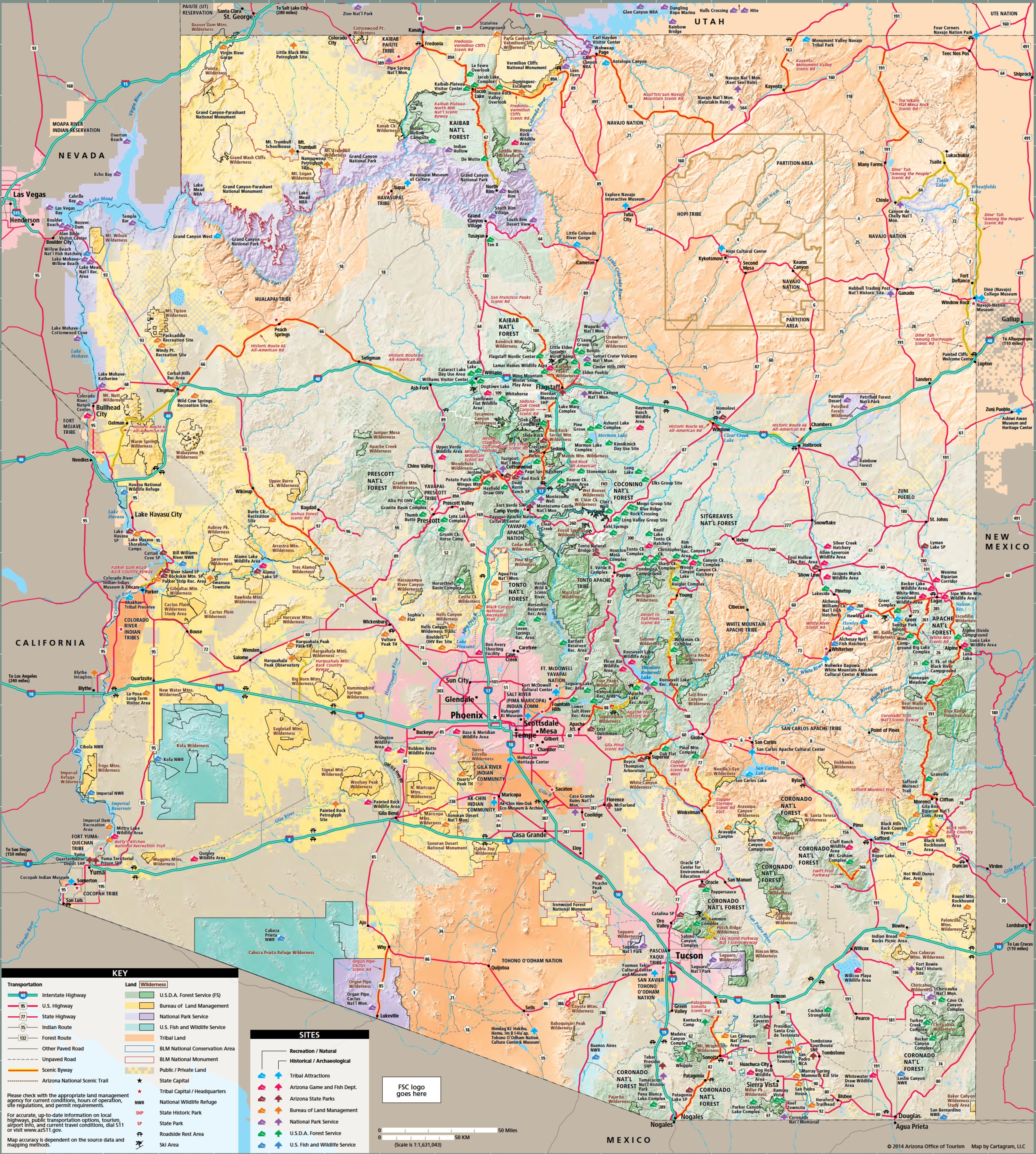
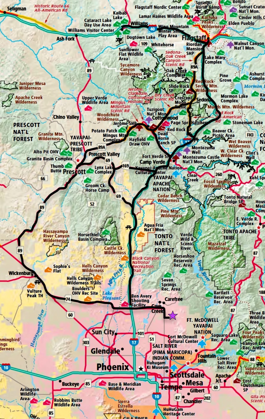
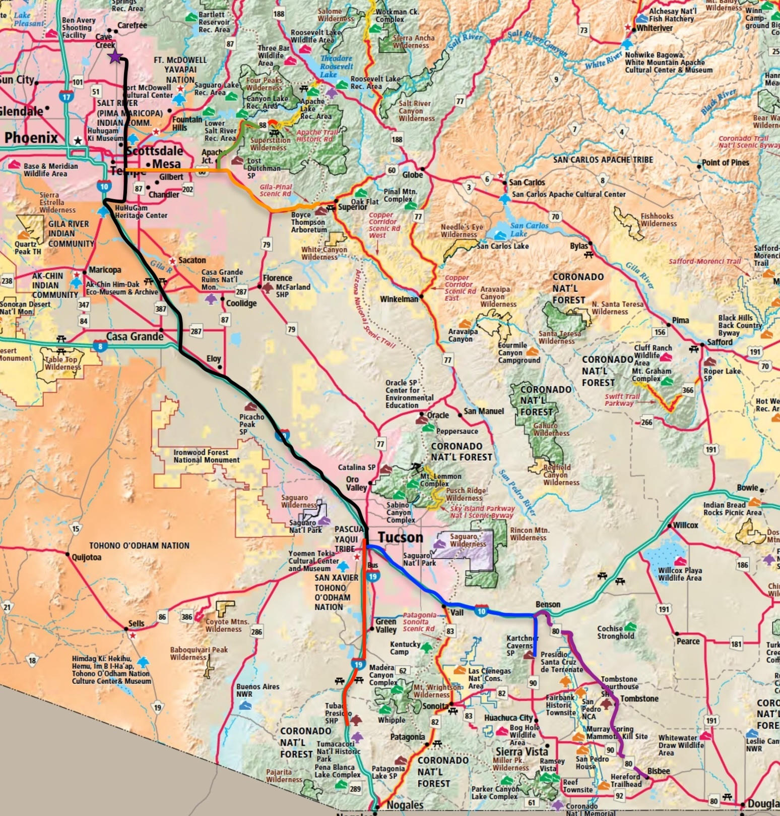
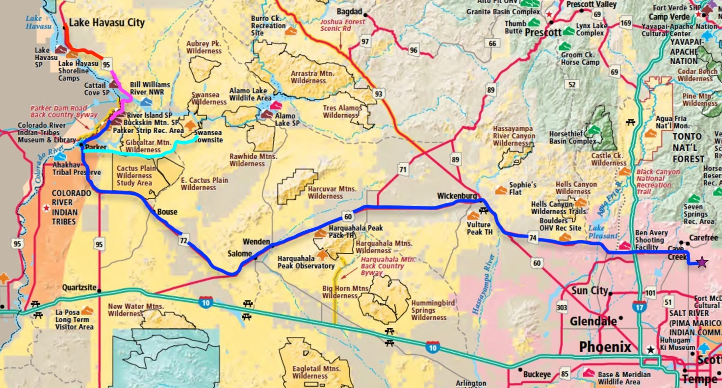
---> Click on the map for a larger view <---
The state of Arizona captured my heart way back in 1999. I came to it chasing a national racing series. I arrived in Flagstaff after dark and a day of driving. I'd left Wichita early in the morning and driven westward to get to my next race in Anaheim, CA. The scenery had been pretty but I wasn't prepared for what I was going to see the next day. I'd been through the flat lands of the central United States that afternoon and I could see mountains in the distance but overall there wasn't a lot to write home about. It was pretty flat and featureless other than some of the terrain starting to look interesting. The sun went down and my view became nothing more than that of the black strip of asphalt in my headlights. I got into Flagstaff, found a hotel to spend the night in and hit the sack. I must say it was nice having a bed underneath me. The previous night was spent sleeping in the back of my van, sharing it with the ever present dirt bike that traveled with me. Ya never know when you'll come across a riding area...
I awoke to about six inches of snow covering my van and trailer and about two hours of driving left to get to Phoenix. Flagstaff is roughly 9,000 feet above sea level. It sits at the base of the San Francisco Peaks, with Humphreys Peak which rises to 12,633 feet (3,851 meters) above sea level and can have snow on it into May, the highest point in Arizona.
|
I got on I-17 and headed south towards Phoenix. The beginning of the drive started with, as mentioned, snow in the pine tree forest that covered the mountainous terrain. It's beautiful. It wasn't long before I'm headed downhill and into a scenery like no other that I'd seen (and I've driven in 49 of our United States - still need Alaska). The mountain terrain is incredible. About thirty minutes into my drive I see the red rocks of Sedona off to the west. The pines are starting to thin a bit. The highway drops down hill into Verde Valley which is tucked in between a couple of smaller mountain ranges. As I passed 6,000 feet above sea level, the snow just stopped. It was like someone had masked off the terrain and painted snow above the line. I'm now seeing stubby plants and shrubs instead of towering pines. I continue south on I-17 up and over the mountain ridge south of Verde Valley and it flattens out a tad. High desert surrounds me with mountains in the distance. The terrain is grassy with sparse, scattered shrubbery and trees here and there. At mile marker 252 is a rest area called Sunset Point. I had to stop and take in the scenery. It's pretty stellar and still high desert. Right after leaving Sunset Point I-17 takes another down hill run as it snakes towards Phoenix. As I'm traveling along, there at mile marker 250, I get my first glimpse of the icon of Arizona and the Sonoran Desert. I see a Saguaro (pronounced "Swar-oh") standing proudly on the right side of the highway. Wow! I've seen these incredible cacti on nature shows and such but never in person. I made my way on down into Phoenix and met a few people that I'd been talking to over the phone for quite a few years. They took me out on an off road ride and I was immediately hooked on the place. I've never had anywhere speak to my heart like Arizona does. |
So enough of me babbling about my first experience in this incredible state. What I want to do with this page is give tourist a guide of the sights and places to see. Robyn and I have traveled all over the state in our decade of living here and we've found some wonderful places.
I'll start out with the touristy areas and then trickle down to some of the more obscure stuff. I'll try to group things together geographically. Lots of the attractions can be linked together in a loop over a couple of days.
I've set up all the places listed as links and click on any of the pictures for a larger view - especially the map up above.
All time references and distances are based from our house on the north end of Scottsdale.
Day Trips from the R&R Resort (our place)
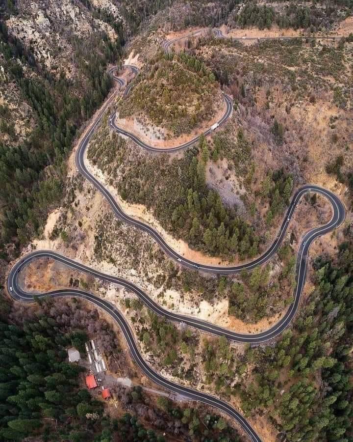
Tourist Alert: Do yourself a favor and start your adventure to Prescott/Jerome/Sedona/Flagstaff by driving out west on the Carefree Highway/State Route 74 to Wickenburg. It's beautiful desert scenery, filled with Saguaros, mountains and lots of really good off roading. It'll end at US 60. Turn right on 60 and head into town. Drive on through Wickenburg to the first round about and take the first exit onto 93. Follow 93 for about five miles and find 89A. It turns off to the right. 89A is a splendid road. One word of warning, though. If you tend to get car sick or suffer from motion sickness at all you might want to skip this route and just head on up I-17 to 260 or 179. As stated, it is a splendid road for a twisties junkie like myself. |
 |
I'm including route highlighted maps to go along with each section. Click on them for larger versions.
Each name below the maps is a direct link to that attraction and is color coded to match the highlighted travel paths.
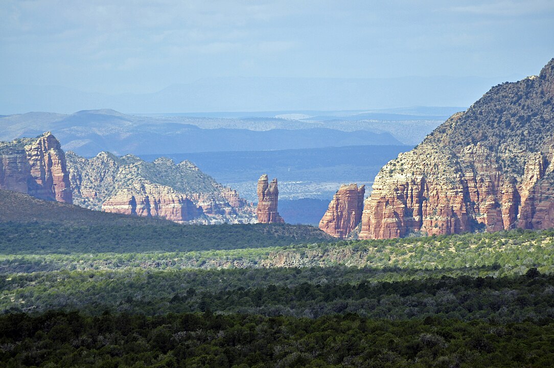
I'll start with what seems to be everyone's "must go to" destination. We've been there enough that we'll generally hand the keys to a vehicle over along with a map and say "Enjoy your day." Tourist Alert: Do NOT go to Sedona Friday through Monday. Those are the busiest days and the place gets crowded. Traffic is thick both on the streets and the sidewalks. Avoid holidays like Valentine's Day, Mother's Day, etc.. Seems Robyn and I always managed to head up on these special days (not even thinking about it being a holiday) and it's crowded. Just under two hours from our house, nestled at the intersection of Highways 179 and 89A Sedona was named after the founder's wife because their last name, Schnebly, wasn't accepted by the US Postal Service. He wanted a post office and they said that their last name wouldn't work so he submitted his wife's name and that was that. Sedona is a pretty magical place. It's surrounded by the incredible beauty of the Red Rocks where hiking and mountain biking are world renowned. It has all sorts of art galleries, jewelry shops, restaurants, Pink Jeep tours, UTV rentals, hotels, more shopping, more restaurants. It's a tourist place after all. It's also a very spiritual place. There are magnetic vortexes all around due to the high iron content in the surrounding rocks - hence the red coloring of them. Some people say it's voodoo and poppycock, others claim it has healing powers and puts them in connection with "the other world". I've been through/in a few of these and stand on the fence as to if there's something to it. There's a curios shop that has a seating area around one and I could actually feel something "different" when sitting in it. Can't really explain what I felt but it was a full body experience. If you're coming into Sedona from I-17, on 179, look for the big fiberglass chicken on the left side of the road. Stop in that shop and see what you think. |
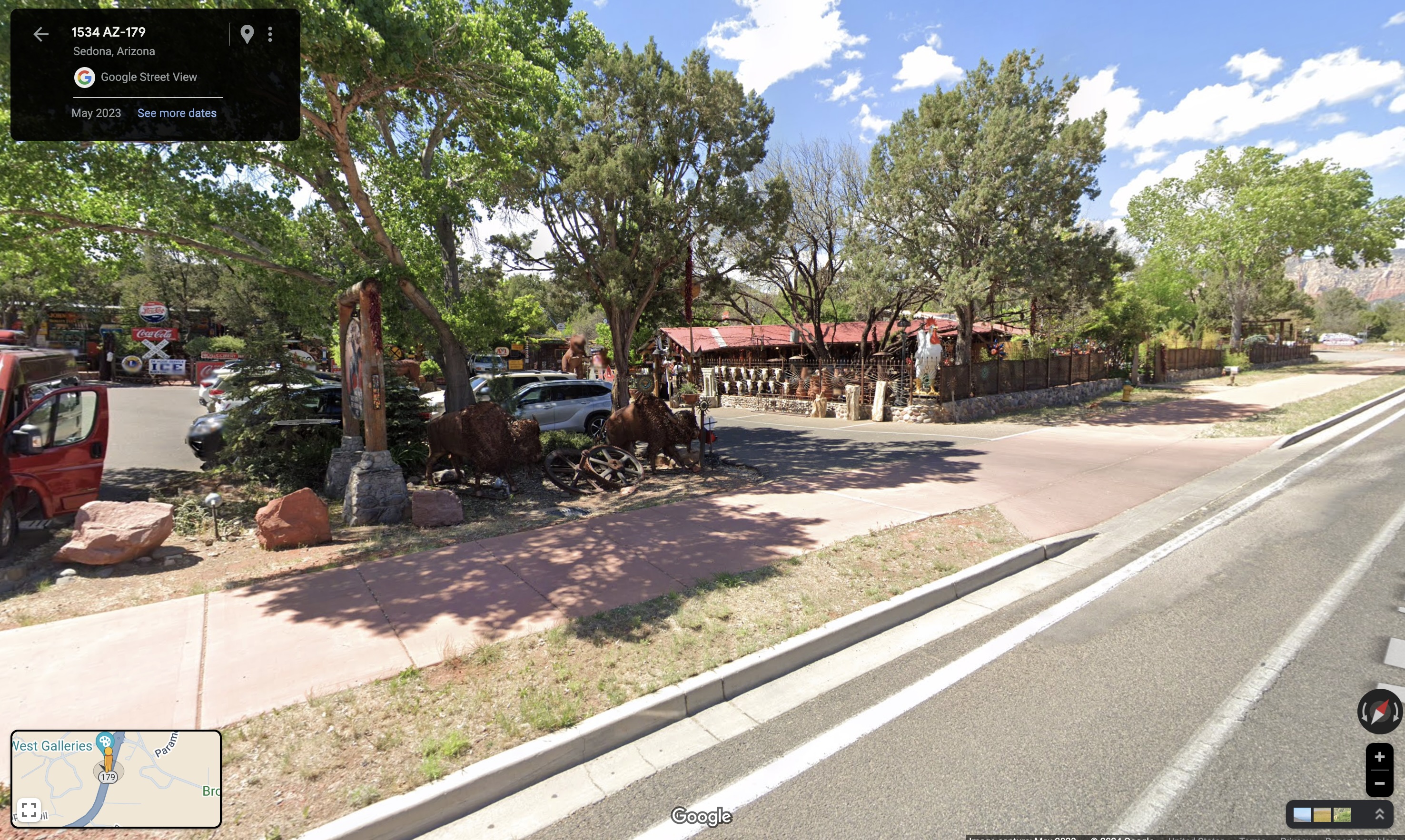 You thought I was kidding about the chicken, didn't you. |
Feeding one's self is a must while in Sedona. The main drag, where you've turned to the right at the last roundabout where 179 runs into 89A, is the center hub of tourism. On the right side of the road shops abound. There are a few places to eat - mostly quick in and out, on the go types of eateries. Grab a sandwich, beer and take a seat out on the deck and admire the scenery. See if you can find Snoopy Rock as you sit there. If you want Mexican, check out Oaxaca on the left side of the road, just before you leave town on 89A north. Head down south on the sidewalk a block or so and get ice cream and/or fudge for desert.
While you're in this section of town stop in and get a psychic reading at the Sedona Crystal Vortex.
Another fantastic place to eat is Mariposa a Latin inspired grill. The place is rather upscale so dress accordingly. It sits on top of a knoll and has a spectacular view of the Sedona landscape all around. I recommend dining outside and getting reservations. It's on 89A.
The owner of Mariposa, Lisa Dahl, also has four other restaurants. There's Pisa Lisa which has probably the best pizza in Sedona, Cucina Rustica, a rustic Tuscan grill, Dahl & DiLuca Ristorante Italiano, and finally Butterfly Burger. While we've not dined at all of them I'd say they're all on the same level of excellence.
If you're into shopping, you should stop at the Tlaquepaque Arts and Crafts Village. It's a very interesting place where the trees grow out of the floor and through the roof. Also treat yourself to Exposures International Gallery of Fine Art on 179 as you come into Sedona from I-17. It's worth stopping in just to gawk at some pretty incredible artwork.
One other place I recommend taking the time to check out is the Chapel Of The Holy Cross. It's pretty amazing. Check out the house down to the right as you look out of the Chapel. It's owned by the man who invented the equipment used in Lasik vision correction and has a water feature that runs through the place. You can't go in, just gawk from above.
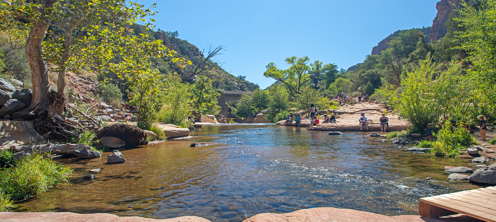
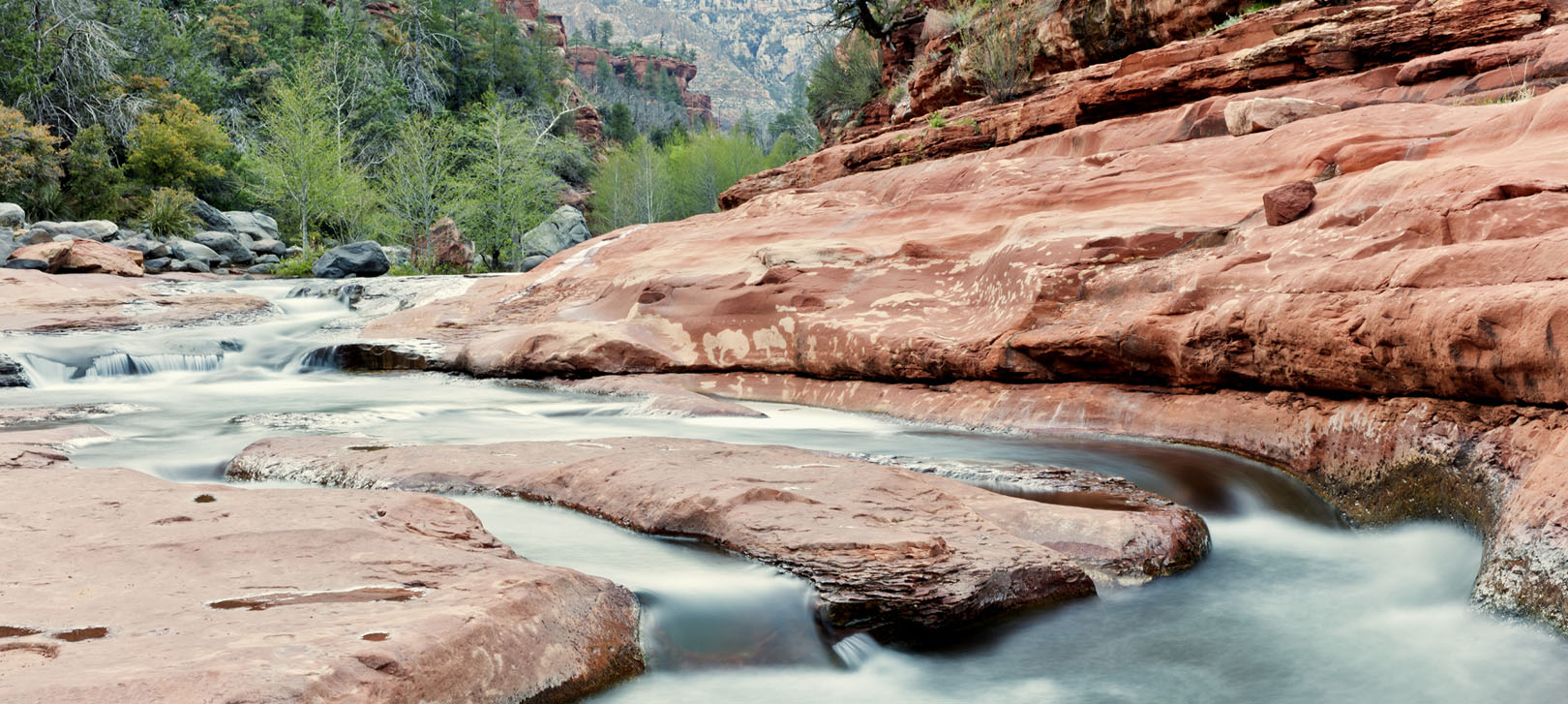
North of Sedona a few miles on 89A is Slide Rock State Park. The water of Oak Creek is crystal clear, cold and flows through a beautiful section of rock. During the summer months it feels great to get into and splash about. The park was originally a homestead apple farm. Many of the buildings and some of the equipment is still present.
 |
 |
While you're already north of Sedona on 89A head on up to Oak Creek Canyon and take a look. The drive is beautiful (and fun if you're a twisty road kinda person) and only fifteen minutes or so. The views are breathtaking and you can purchase jewelry and trinkets from the local Native Americans. They have tables set up with their wares spread about on display.
Tourist Alert: Use the facilities and make your bladder gladder. For some reason the timing of having lunch in Sedona and then getting to Oak Creek Canyon's overlook requires a visit. The facilities are generally pretty clean and tidy.
Okay, back to Sedona after a drive up to Oak Creek Canyon.
We've only been there once and it was lovely. It's a quaint, proud little mountain town. It has a beautiful town square and there's an abundance of of restaurants, shopping and lodging.
Prescott has a very chill vibe. We want to go back and explore it a bit more. You can get there via 89A or you can take I-17 to 69 and follow that in. This route is about 65 miles and will take about and hour fifteen to get there.
Tourist Alert: Pronounced "Press-kit", not "Press Scott" (that would be rude to do to him anyhow...) They WILL correct you, politely.
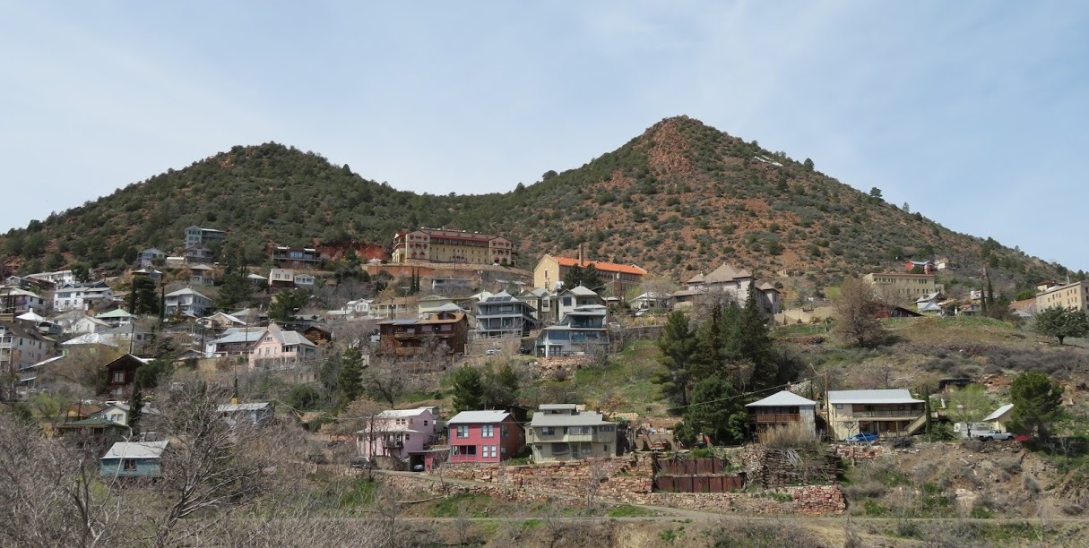
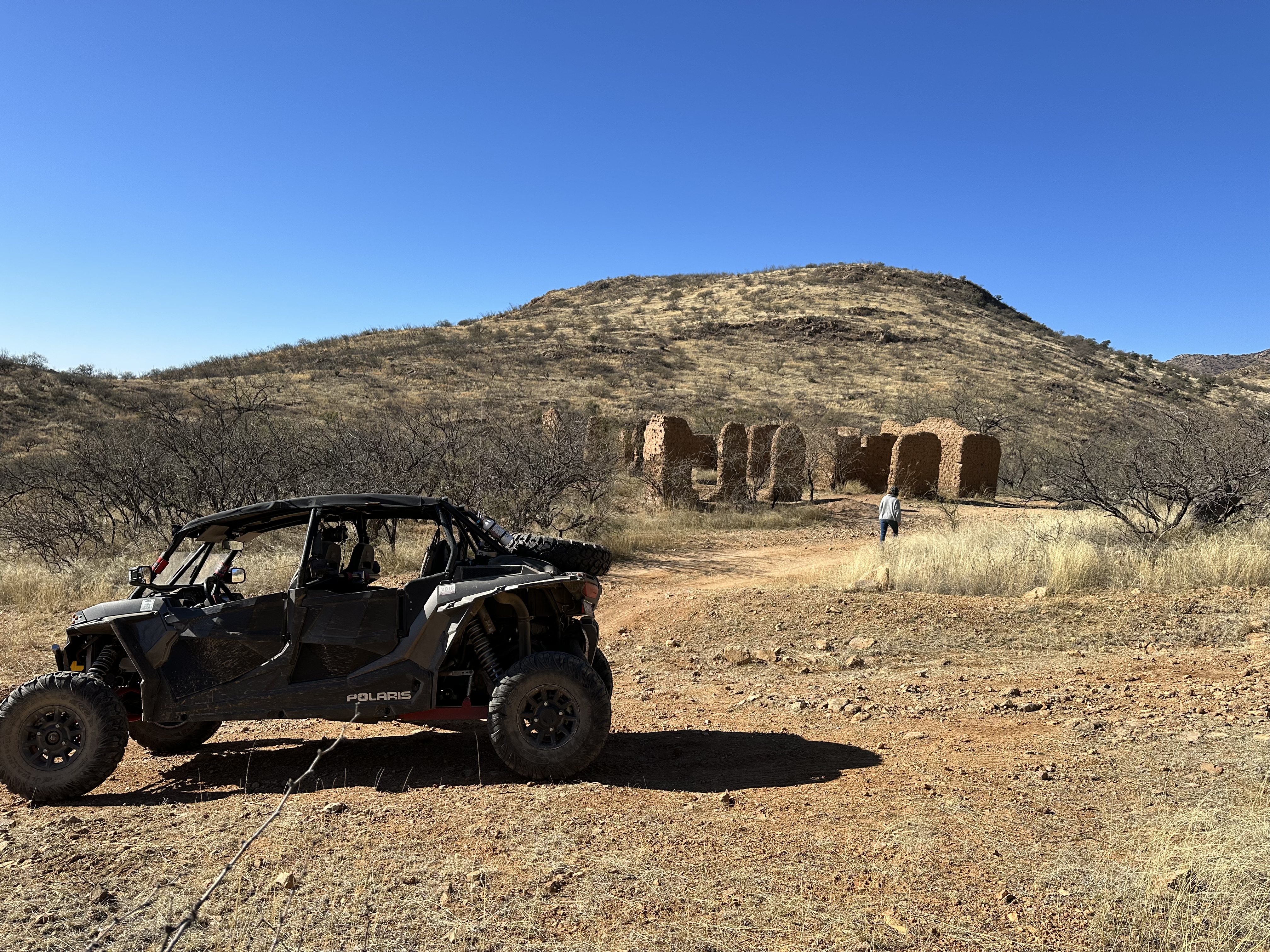
Jerome has to be one of my favorite day destinations. About an hour and a half from us, Jerome is located near the top of Cleopatra Hill between Prescott and Flagstaff on 89A is the historic copper mining town of Jerome, Arizona. Once known as the wickedest town in the west, Jerome was born a copper mining camp, growing from a settlement of tents into a roaring mining community. After its founding in 1876, Jerome was at one time the fourth largest city in Arizona with the population peaking at around 15,000 in the 1920's. (these two paragraphs are stolen from Jerome's web page) Jerome is a really interesting place. It's haunted, it has some pretty wild history and is nestled in the side of the top of a mountain. Go check out the Jerome State Historic Park and learn about the mining that brought the town to life. Right next to the park is the Audrey Headframe which sits on top of a 1,900 foot deep mine shaft. The top of the shaft is covered in glass and you can stand on it and look down. The mine shaft is 650 feet deeper than the Empire State Building is tall. Back in town, Jerome has some very eclectic shops to wander about. I'm always intrigued by Nellie Bly, Kaleidoscopes, Art Glass and More. This place is actually where I got the inspiration to build my kaleidoscopes. Just down the street from Nellie Bly is Caduceus Cellars and Merkin Vineyards which is owned by Maynard James Keenan of the band Tool. |
 |
Drive into town on Main street and as you get to the fire station, go straight and check out the Gold King Mine Ghost Town. The collections of stuff, from toys to mining equipment is just amazing. You can easily spend a day wandering around the property.
Tourist Alert: The steps in Jerome Park are full of the ashes of many of the miners from a hundred years back. |
 |
Food in Jerome doesn't disappoint. The Haunted Hamburger is great. It has a deck that looks out over the valley and the burgers are fantastic. Bobby D's BBQ & Grill has to be some of the best BBQ I've had outside of Texas. Grapes Restaurant and Bar is another really good place. As I write this (7/20/24) it's listed as closed for renovations. Hopefully it'll be open when you travel to Jerome.
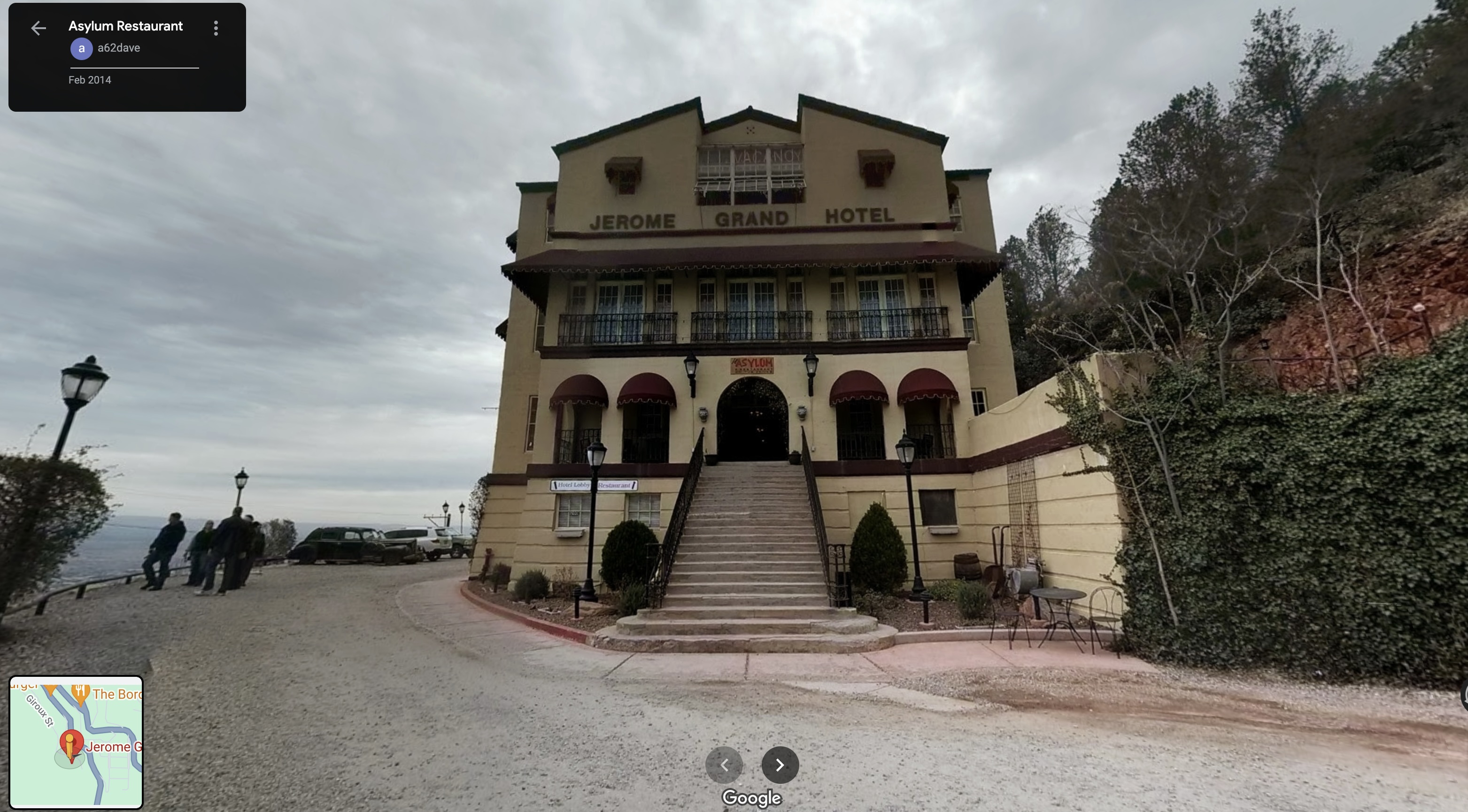
Another place that we'd like to stay and 'take our chances' is the Jerome Grand Hotel. It's the site of the old hospital and mental asylum and is supposed to be one of the most haunted buildings in Jerome. The story goes that there were a lot of untimely deaths in the building and many of the spirits still walk the hallways. The food there's really good too.
This is a blast to do. It goes out of Clarksdale, which is just a few miles up the road from Jerome.
The train is fairly historic and takes you to an old ranch. The trip up is right at three hours and the ride home is one. The train follows the Verde River and the scenery is just wonderful where you see lots of greenery amongst the desert landscape. There's quite a bit of wildlife to be seen too.
There are different packages to purchase for the train ride. General admission, caboose, etc.. We've found that we generally spend most of our time riding in the open air viewing cars.
This is a great way to spend the first part of the day. Head up to Clarksdale, ride the train and then head on down the road to Jerome for the evening.
Tourist Alert: Wander around the depot in Clarksdale. It has some interesting history and, of course, a gift shop.
To be honest, I've not really done much in Flagstaff other than get onto I-17 to head to Phoenix or to get to I-40 to travel back east. The trip is about two hours, providing I-17 isn't crowded or shut down for a crash. We do our best to avoid driving I-17 on Friday or Sunday afternoon. I've spent the night and we've have a few dinners there when we've stayed at Fort Tuthill. Flag has a lot of things going on, as it's a progressive college town. You can go skiing in the winter at Arizona Snowbowl or head on up to the Grand Canyon and farther north. We also rented off road bicycles one weekend to go exploring the area around the Fort Tuthill Recreation Area.
Flagstaff is a bit like a center hub for doing things in the northern half of Arizona. Meteor Crater is off to the east about forty five minutes or so, Williams is thirty minutes west, the Grand Canyon and Page/Glen Canyon are north of it on 89.
Fort Tuthill isn't really a destination as much as it's a place to stay for a few days as a base camp and explore from there. It's about a ten minute drive up to Flagstaff up 89A so it's pretty convenient to groceries and dinner and such.
They have camping, including RV spots, tent areas, cabins and yurts that you can rent, rodeo grounds (I think they probably do the county fair stuff here) and Flagstaff Extreme is right next to the Fort Tuthill Recreation area. Flagstaff extreme is a blast - took me four times to finally complete all the courses (lighting stopped us once, the people we were with stopped us once, I pooped out once and then I finally completed the full course.) It has a combination of zip lines and adventure course obstacles and is a challenge to complete.
There's a lot of hiking around Fort Tuthill and there's a bicycle park with obstacles from beginner to "OH *&%^ I shouldn't be here!" (true story as I stood on a 4" wide board trying not to fall off the wall) It's my understanding that there's rafting somewhere in the area too.
Tourist Alert: If you're lucky you might stay during the rodeo. The county fair grounds are on Fort Tuthill and they hold rodeos there.
|
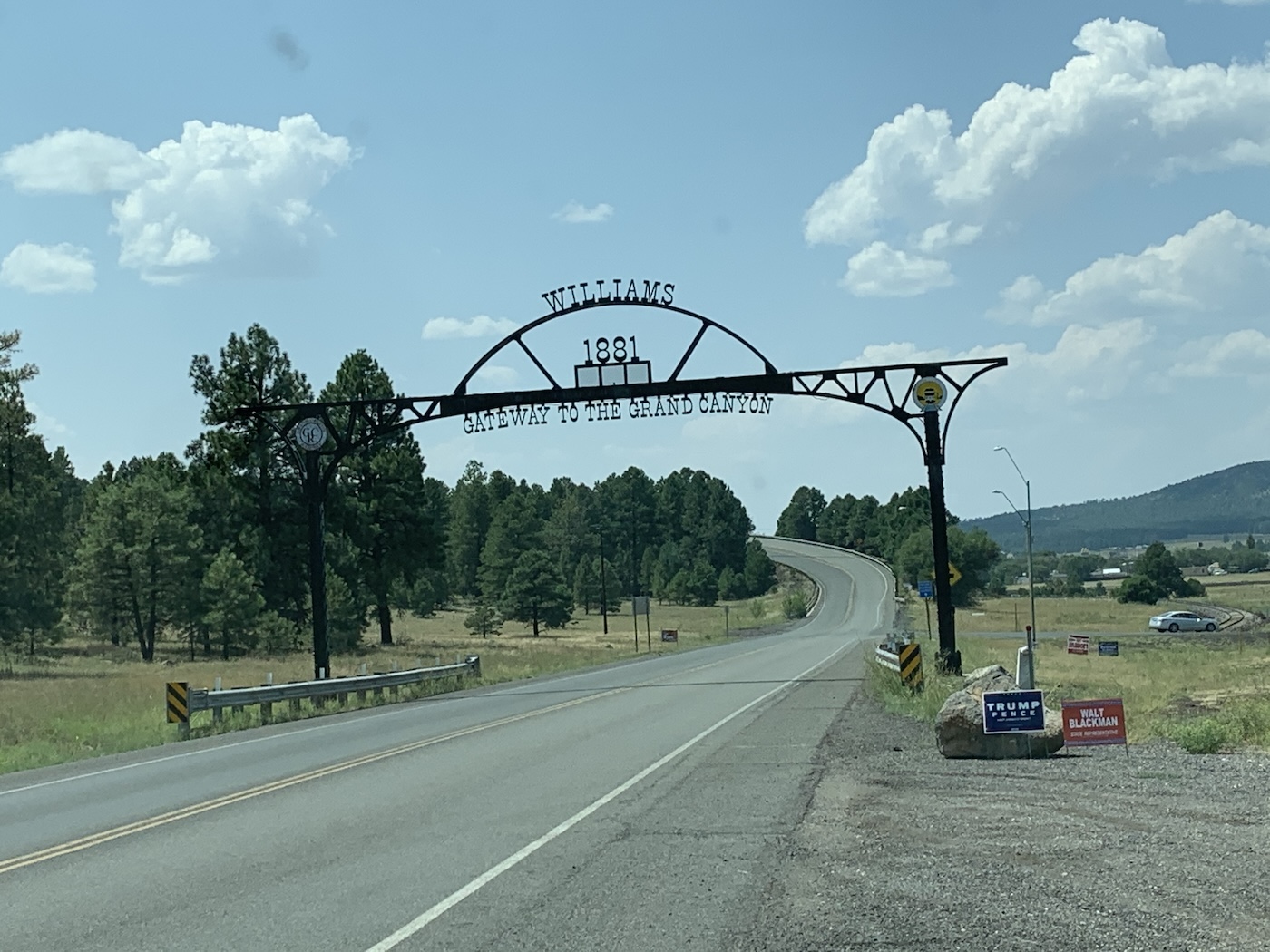
I'm actually sitting about two and a half hours away from home in the Circle Pines KOA Campground, just outside of Williams as I type up this page. Williams is a pretty cool place. It's one of the many little towns that sits on Historic Route 66 and it completely embraces it. It's like dropping back sixty to seventy years in history when you wander around the place. Downtown totally ebraces it's history and the little shops, restaurants and hotels all look like they just stopped being "in the present" years ago. If you're lucky enough, you'll come across one of the locals that knows all the history and is more than happy to share it with you. His point of view is very comical and entertaining. Quite the street corner storyteller, he is. There's also a Zip Line and a single seat roller coaster (new to the place, it was crowded and we didn't feel like waiting). I'm sure Google-fu will find either of these places if you look. If you happen to have any way to go exploring off road, say in a Jeep or UTV, there are miles and miles of trails around Williams. Most are Forest roads and smooth/easy to travel. Dogtown Lake and Bill Williams Campground are really nice (we've only driven through) and Spring Falls is absolutely breathtaking. You can follow the rail road tracks also. There are access roads that the rail companies use for maintenance and such and they make great cross country routes. Railroads get to see all the really good stuff that's not on the beaten path. Below I've listed/linked two things that we've done in Williams that I think are definitely "To Do". |
|
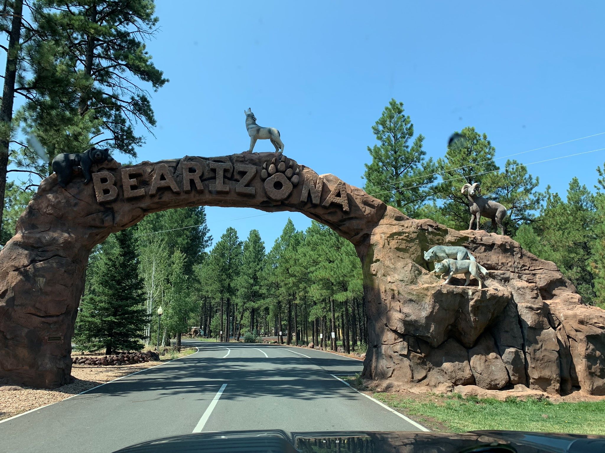
Bearizona is Arizona's Premier Wildlife Park (or so the web site says). You can't miss it, as it's right off the road heading into Williams. It's a nice, small zoo. They have animals from all over the area (many are rescue/rehab patients) on display. There's a drive through only area where the animals can come right up to the car and there's a walk around area with nice open displays where the animals seem to be pretty comfy. There's a restaurant and a grill, a coffee shack, a creamery and a bar on the premises. Tourist Alert: Don't feed the animal, please. Well... Unless you get the food they have just for them, there in the park. |
 |
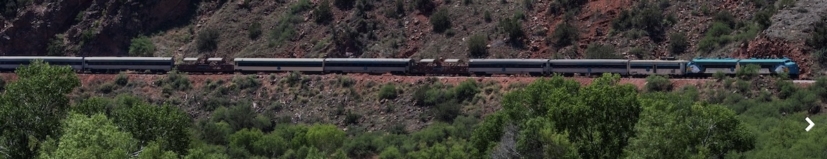
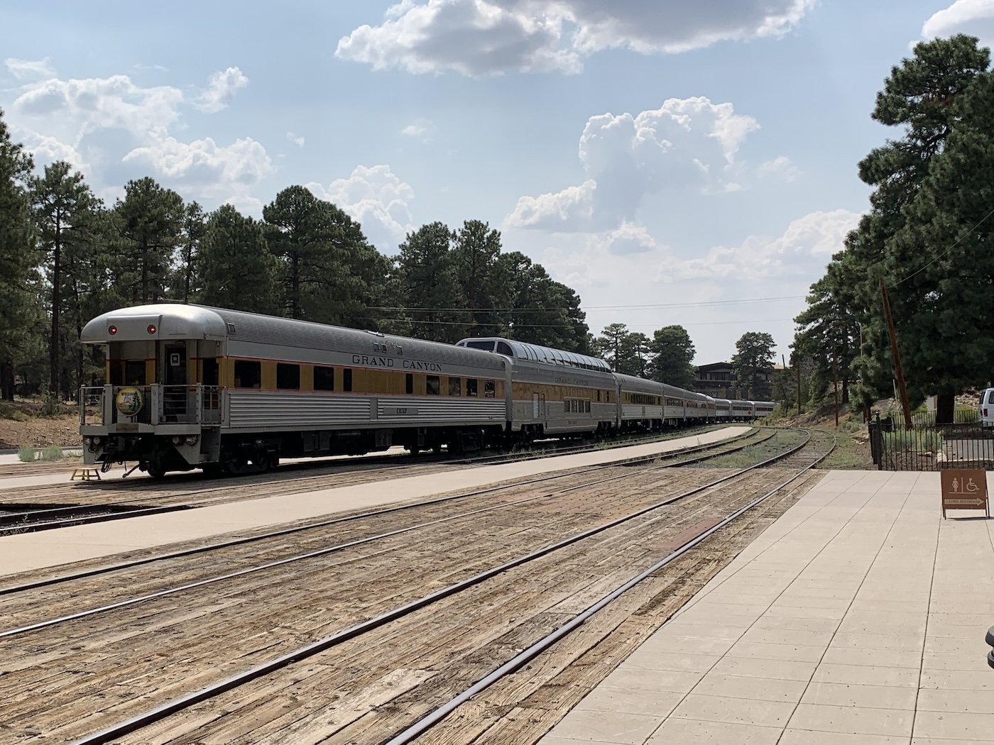
|
The train runs out of Williams daily to the Grand Canyon's southern rim. The ride is a couple of hours each direction if I recall correctly. It traverses the land, starting in the pine trees that surround Williams and then heads out over the high desert plains. You get to see all sorts of landscapes during your ride. They pull into the Grand Canyon Village and let everyone off to wander around. You can make a day trip of it or you can make a full vacation out of it and spend a couple of nights and hike the canyon. We just did the day trip. Tourist Alert: You may just be the victim of a hold up! |
 |
 |
|
|
Meteor Crater Natural Landmark
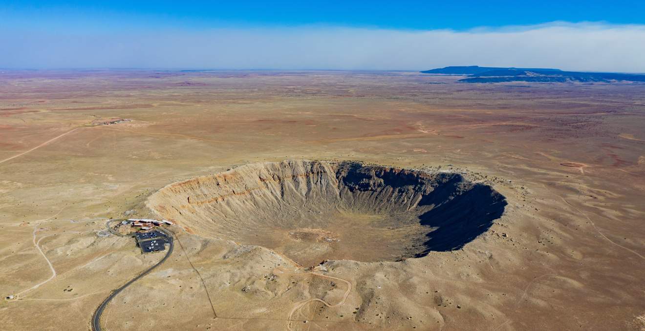
Ever see the movie Starman? This was his destination to return to the stars. It's also quite spectacular to observe.
The Meteor Crater is located about forty five minutes east of Flagstaff and was made about 50,000 years ago when a 150 foot wide meteor struck the high desert of Arizona. It made a hole in the ground that's 550 feet deep and just under a mile across. Its vastness is impressive. NASA used the crater for training for moon landings.
Tourist Alert: Once you know what to look for on the desert floor, it sticks out like a sore thumb and you can actually see it from I-40.
Apache Junction has quite a bit of historical places in and around it. Elvis and John Wayne both filmed movies in Apache Junction. The buildings used in some of the sets, along with a church that still stands are quite interesting to take a look at. There's a lot of hiking and off roading in the area too. Bulldog Canyon offers some pretty rugged off roading. Rent a UTV or Jeep and go explore the area. Of course I have to mention food, and of course Mexican food. Go find Los Gringos Locos on Phelps Drive. Good stuff. Goldfield Ghost town looks like it's still stuck in the beginning of the last century. It was a thriving gold mine in the 1890's until they hit an underground spring that ended up flooding the mine out. There's still some mining going on there. Tourist Alert: Watch out for the town drunk and the gun slingers. You may just get caught up in a shoot out. I also highly recommend taking the little train that circles around the town. The conductor is a character and tells of the history of the town. |
Not really sure what to say about the Museum other than all the tourist stuff I've been researching says it's pretty cool. I guess it has history of Apache Junction and the Superstition Mountains. The Lost Dutchman Mine is the stuff of legends and people still loose their lives searching for it.
Tourist Alert: If you do ANY hiking at all, do NOT go out if it's above 100F/37.7C Too many tourists and locals for that matter, go hiking when the weather is dangerous and end up making the local news. The heat is one of Arizona's biggest killers.
We just went here this past spring with our cousins. It's about an hour and a half from the R&R Resort, out on US60. The place is beautiful and a lot of fun to wander about if you like plants and nature. Hit the link and take a look.
Tourist Alert: Don't go here if you're not a hiker. While it's only a couple of miles of trails, it requires walking to see it.
Over Night Adventures
The places listed next need more than a day to really enjoy them. Lots of them are Parks, both National and State. Tourist Alert: We have a travel trailer that our RZR UTV fits in it so we go camping and exploring often. I highly recommend renting an RV and exploring with that. |
|
Southern Utah is way to close to not mention as an overnight destination. It has some of the most incredible scenery in the country. I actually think Bryce Canyon is prettier than the Grand Canyon. Zion National Park is just up the road from it and well worth the drive through. You can hit these and make a loop to Las Vegas and then back to the R&R here in Scottsdale.
Grand Canyon - South Rim and North Rim
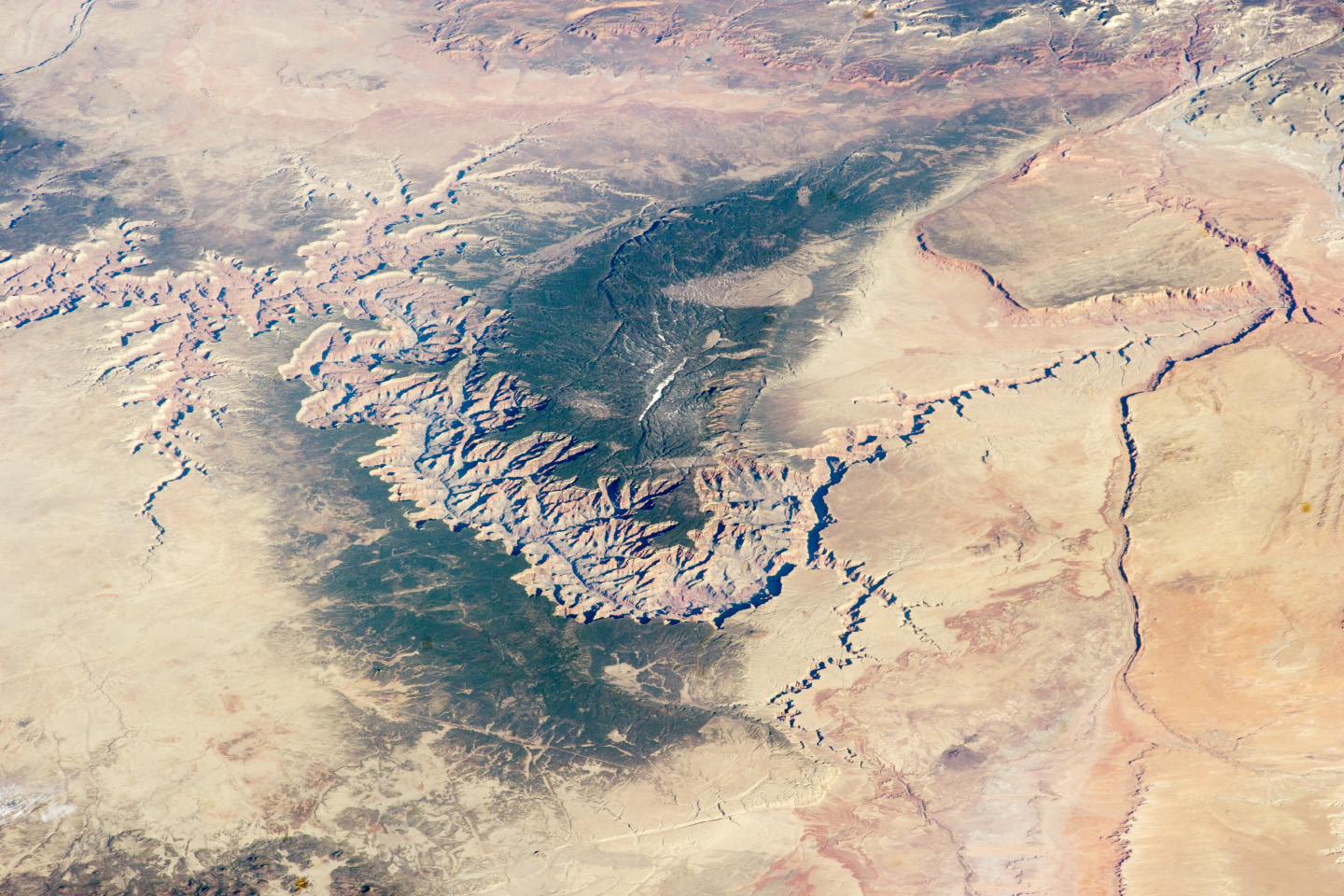 The Grand Canyon from space |
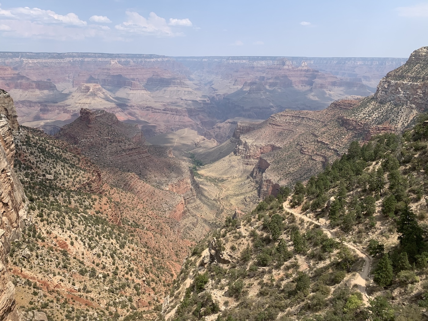
Called one of the Seven Wonders of the World, the Grand Canyon is 277 miles (446 km) long, up to 18 miles (29 km) wide and attains a depth of over a mile (6,093 feet or 1,857 meters) as it snakes through the north western corner of Arizona. I can only comment about the South Rim at Grand Canyon Village and North Rim observation points, as that's all I've been to. I know there's a sky walk somewhere on the south western side but we've not had a chance to explore that yet. The southern entry is about an hour and a half from Flagstaff. Hop on 180 out of Flag and head north to the Grand Canyon Village. You get to take in the vast views of the high desert with its hoodoos and table mesas. The northern entrance is out of Lees Ferry 89A to 67. Turn south there. Pay attention to the change in landscape. It goes from incredible views of the Vermillion Cliffs, which are rocky and almost devoid of any foliage to thick pine forest. It's odd to drive along in the woods and come to the north rim. It's almost hidden as you approach, which is hard to believe. There are quite a few things to do at the Canyon. You can hike, you can ride a donkey to the bottom and spend the night, you can white water raft the Colorado or fall to your death if you're not careful. |
Tourist Alert: On average twelve people die at the Grand Canyon every year. The two most common ways to plummet to your demise are:
A) Getting blown off the edge, as the winds can be a bit funky at times. Gusts will come up out of the canyon and take you for a ride. Just because you can walk right up to the edge doesn't mean you should.
2) Being stupid with selfies. Yes, people will start taking pix, walking backwards and slip off the edge. Don't be stupid.
Hiking is also another main cause of not coming back. If you plan on hiking make sure you have enough water, know where you're going and what you're doing. It's not a place for the family to just go wandering down the trail.
Located about two hundred and thirty miles (375km) from the R&R and about four and a half hours (if you hit good traffic on I-17), Page is another world compared to the Valley of the Sun (Phoenix). On the drive you'll start at about 1860 feet above sea level in the Sonoran Desert. From there you head up I-17 to Flagstaff, at about 7,000 feet above sea level and in the pines. The change is quite surprising. You head on up 89 and about forty miles or so the scenery makes another incredible change. It goes from green pine to open high desert and the northern section of the Painted Desert. The scenery is right out of the old Coyote, Road Runner cartoons. If you ever seen Forrest Gump, where he decides to stop running, that's on the way to Page. The Hoodoos and Mesa are spectacular. Page is at the base of Lake Powell where the Glen Canyon dam stops the Colorado River and feeds the top of the Grand Canyon. It's similar to Flagstaff in that it's a pretty good place to base yourself in and travel out of to go see the sights. There are plenty of places to stay in and there are quite a few really good Mexican restaurants. The busier they are, generally the better the food is. We've not stayed in Page directly. The couple of times we've been there we've stayed at the Wahweap Resort. Our first time was at the camp ground, the second time in the resort. It has a really good restaurant. Tourist Alert: Be warned, parts of 89 are like a roller coaster. If you're pulling a trailer or camper, be prepared for some bouncy times. Also, it's only two lanes with a passing lane fairly often. Be patient and wait until you have ample time to make a pass on someone. Emergency services are a LONG way off. Oh, it's also a myth that you can blast across the reservation lands without the fear of getting pulled over. The cop was REALLY cool, though... |
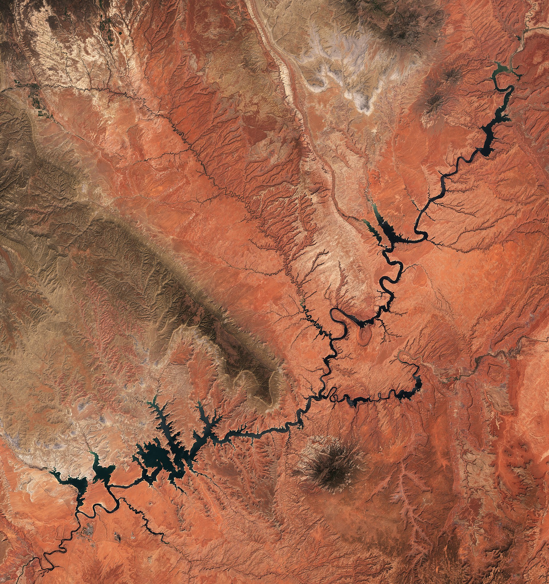 Lake Powell From Space By Copernicus Sentinel-2, ESA CC BY-SA 3.0 igo, Link |
I wish I had more info on Lake Powell but I've not really done anything there other than paddle a two person inflatable canoe across a finger and take a boat ride up to the Antelope Canyon.
It is the second largest lake in the US, after Lake Mead, it has more shoreline than any other US lake too. I've a good friend who's been trying to get me to go spend a week on a houseboat in September for many years now. I need to go and experience it.
Glen Canyon/Glen Canyon Dam and Lees Ferry
These two places are on the Colorado River. The Glen Canyon Dam is just out of Page and there's a parking area where you can stand on the old bridge and look down over 700 feet (220 meters) into the canyon to the water. Lees Ferry is 42 miles (61 km) from Page via Hwy 89 south and Hwy 89A west. It is 85 miles (125 km) from the North Rim of the Grand Canyon via Hwy 89A and Hwy 67. The Lees Ferry Junction and Park Entrance is in Marble Canyon, just west of Navajo Bridge Interpretive Center. A paved road leads 5 miles (8 km) to the Ferry area. Lees Ferry is the only place within Glen Canyon where visitors can drive to the Colorado River in over 700 miles of canyon country, right up to the first rapid in the Grand Canyon. A natural corridor between Utah and Arizona, Lees Ferry figured prominently in the exploration and settlement of northern Arizona. Lees Ferry is now a meeting of the old and the new. Here at the very start of the Grand Canyon, adventurous river runners launch their boats for trips down the canyon. (I stole these three paragraphs from the National Parks web site.) Tourist Alert: If you're not into heights, you might not want to look down. It's a looooong way to the water. |
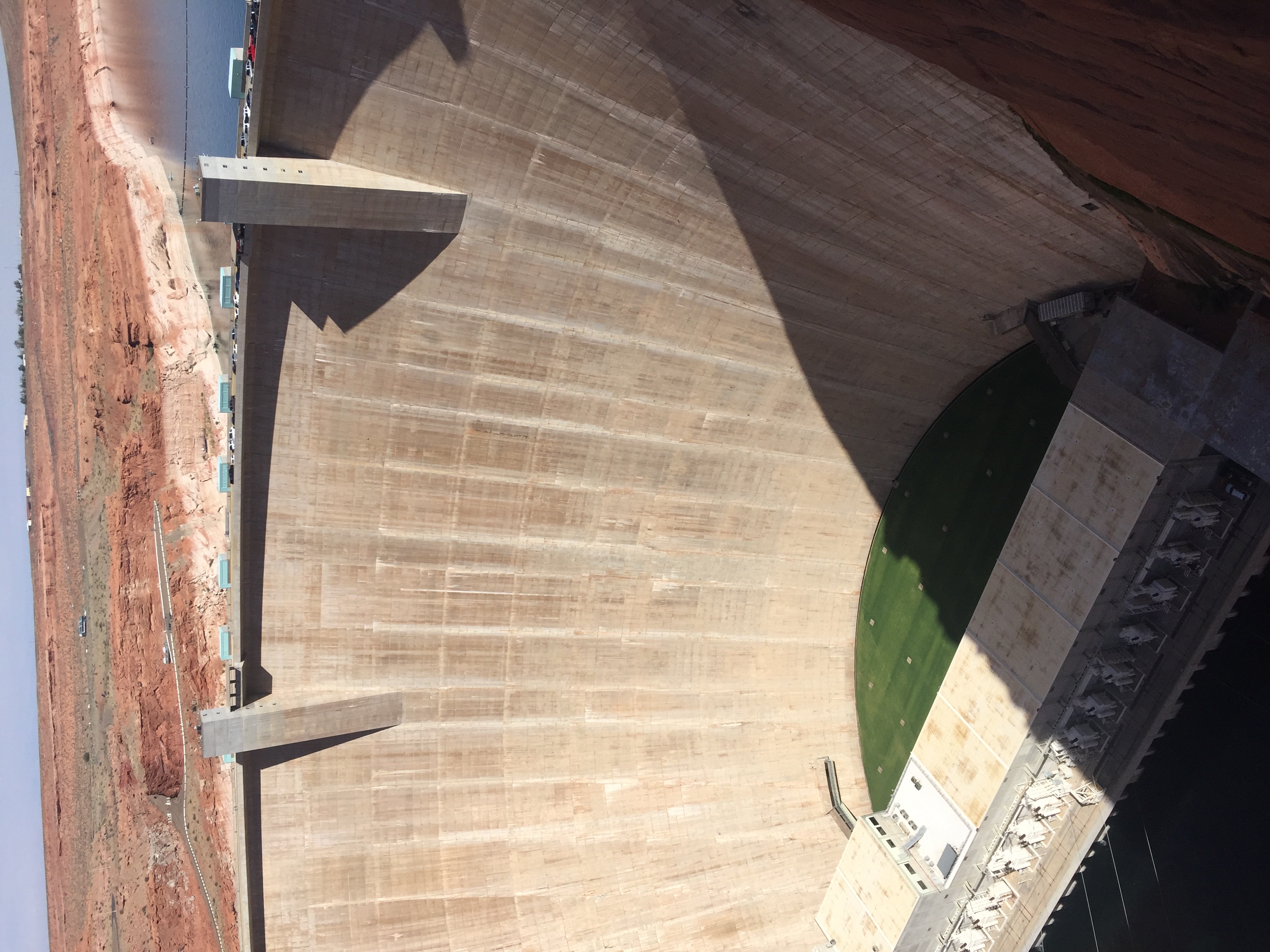 Glen Canyon Dam |
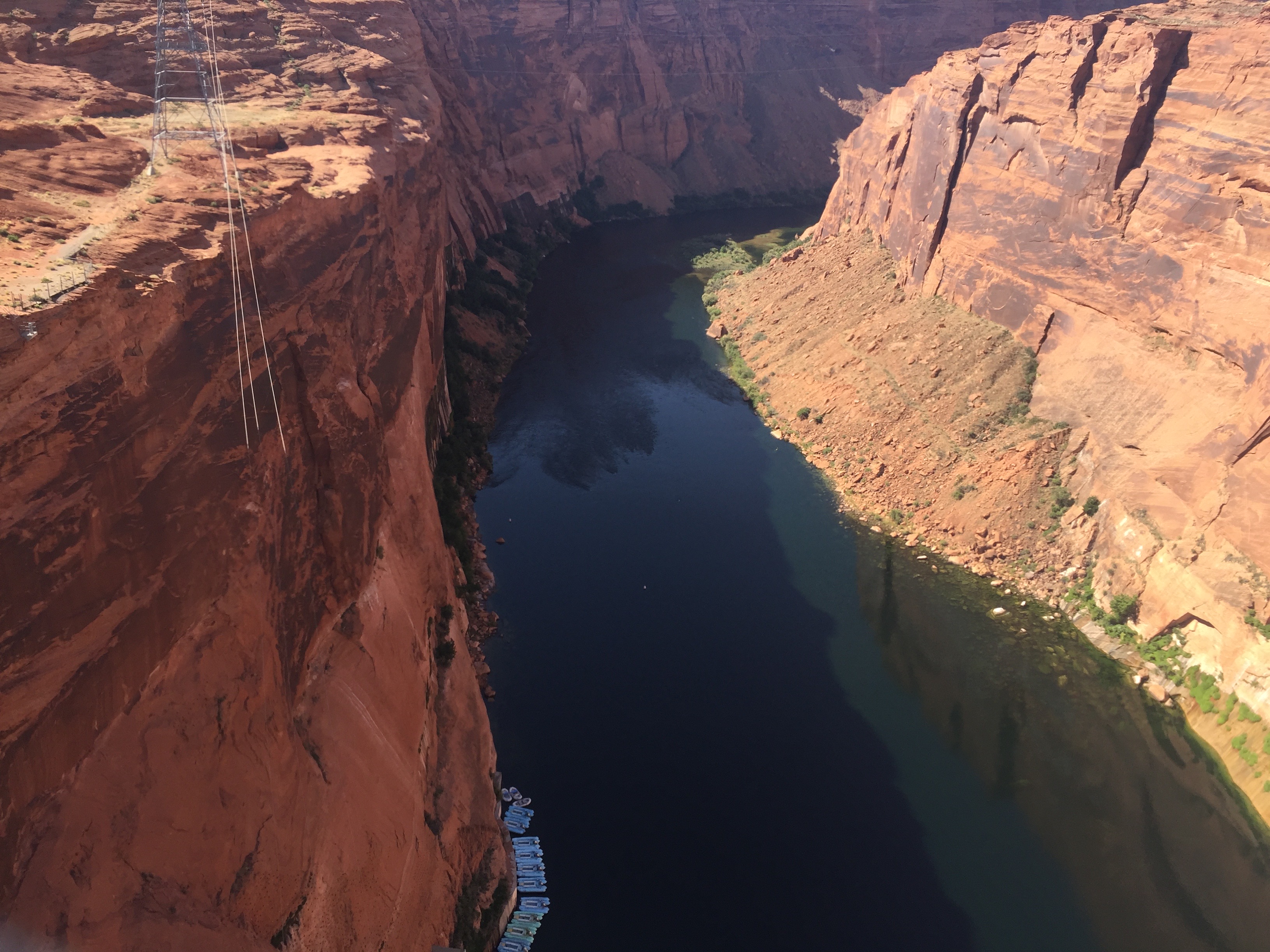 Glen Canyon |
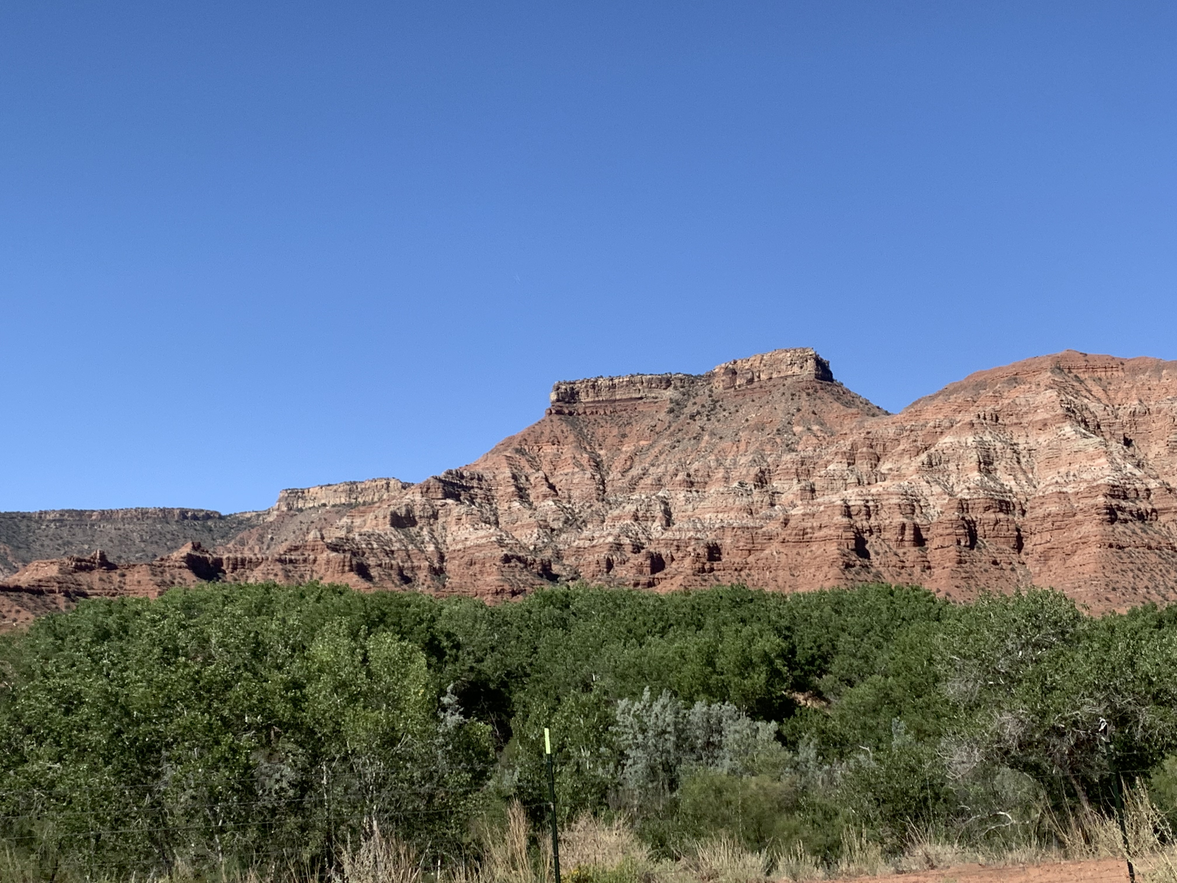
The Vermillion Cliffs show some of nature's ability to do the unbelievable. Huge rocks stacked on top of little stands. These are all along 89A as you drive towards Jacob Lake and the north entrance to the Grand Canyon. The mountain range and cliffs are spectacular to look at as you drive along 89A. They're about an hour out of Page and something you'll see on the way if you go to Utah. There's The Wave and Vermilion Cliffs National Monument that you get to off of 89A. My understanding is that there's a 30 mile dirt road that takes you to it. We've not been there (yet). Tourist Alert: Take a look at all the rock formations and cliffs as you drive along 89A. The sights are pretty incredible. |
 |
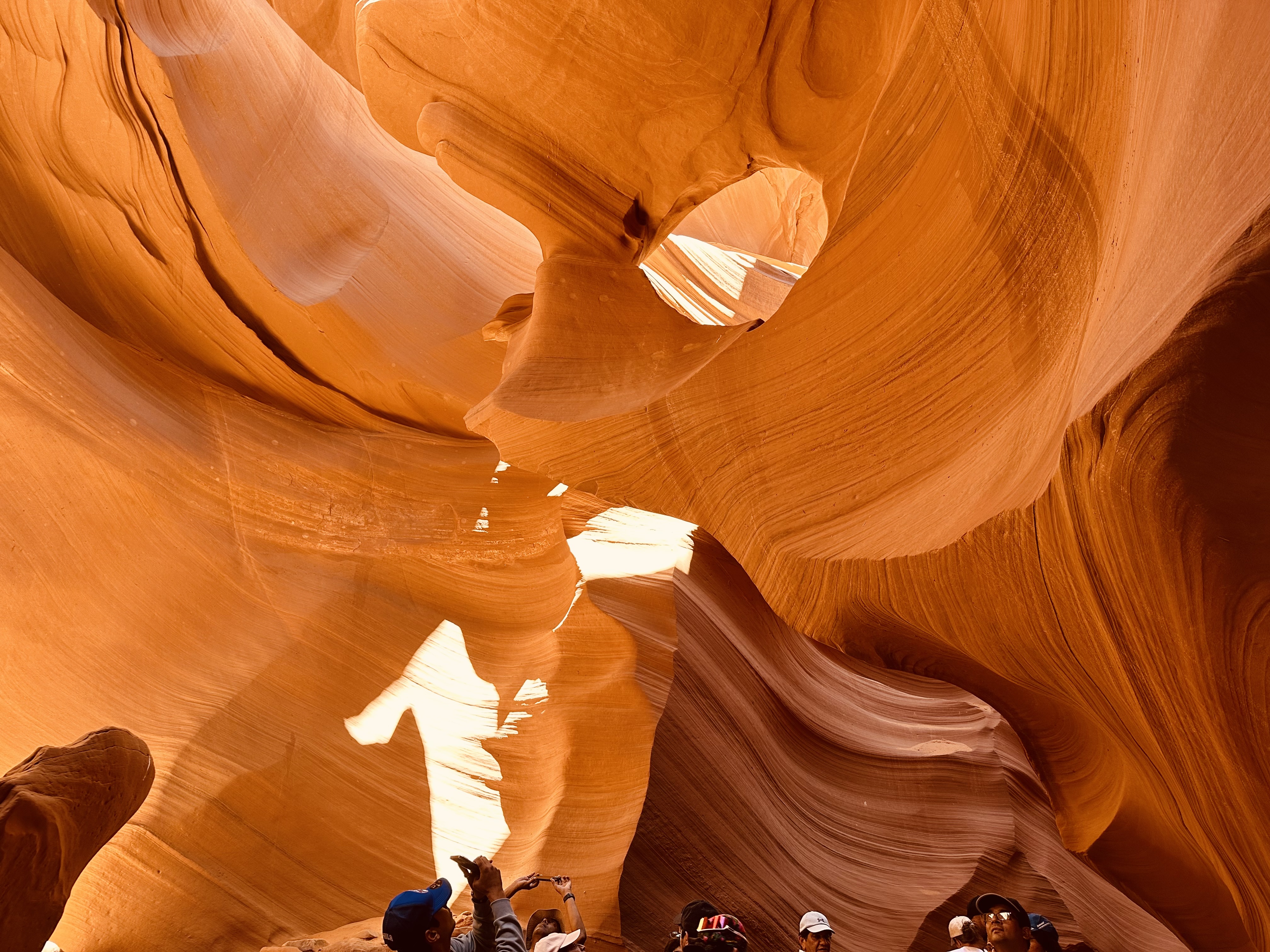
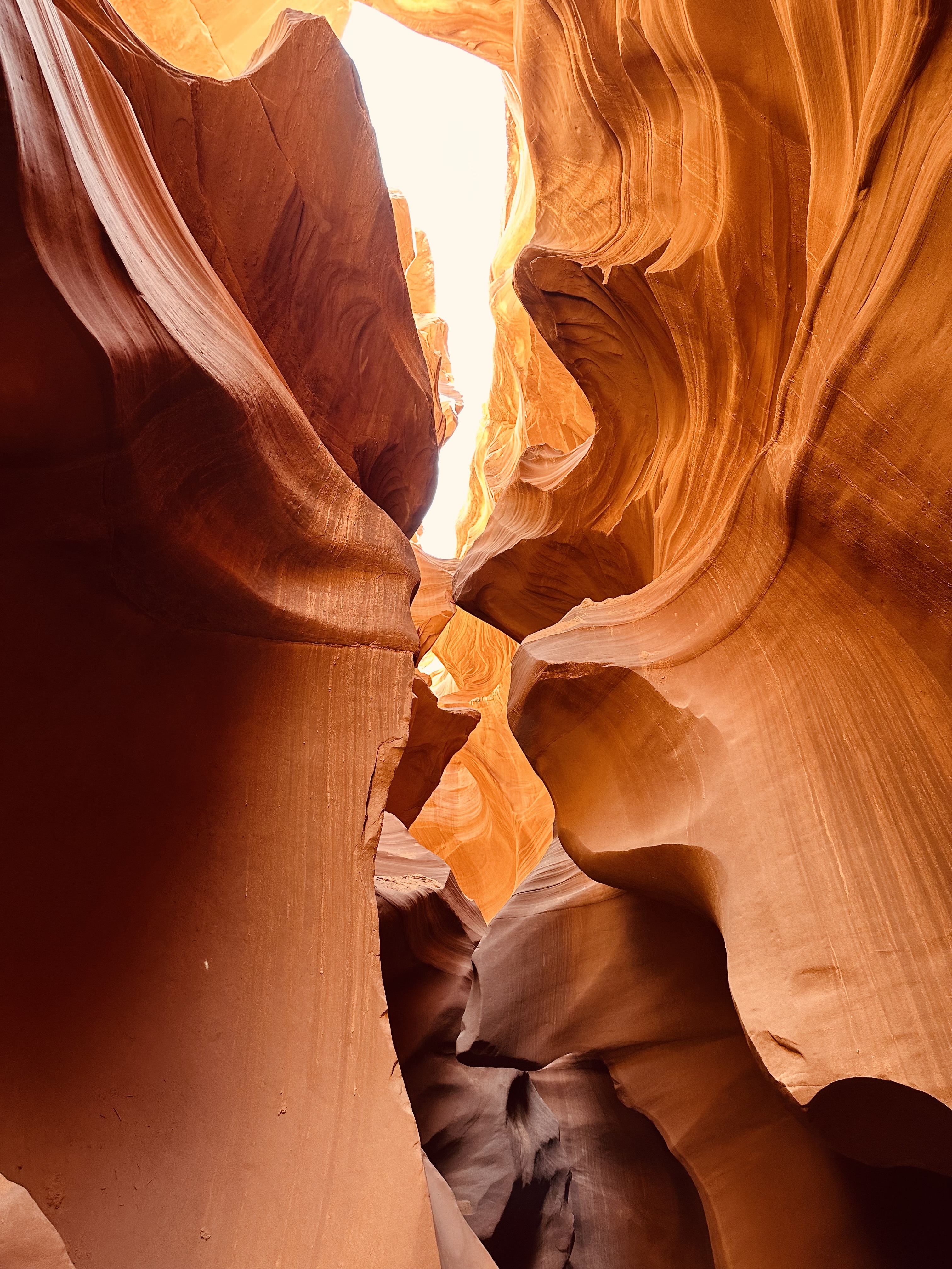
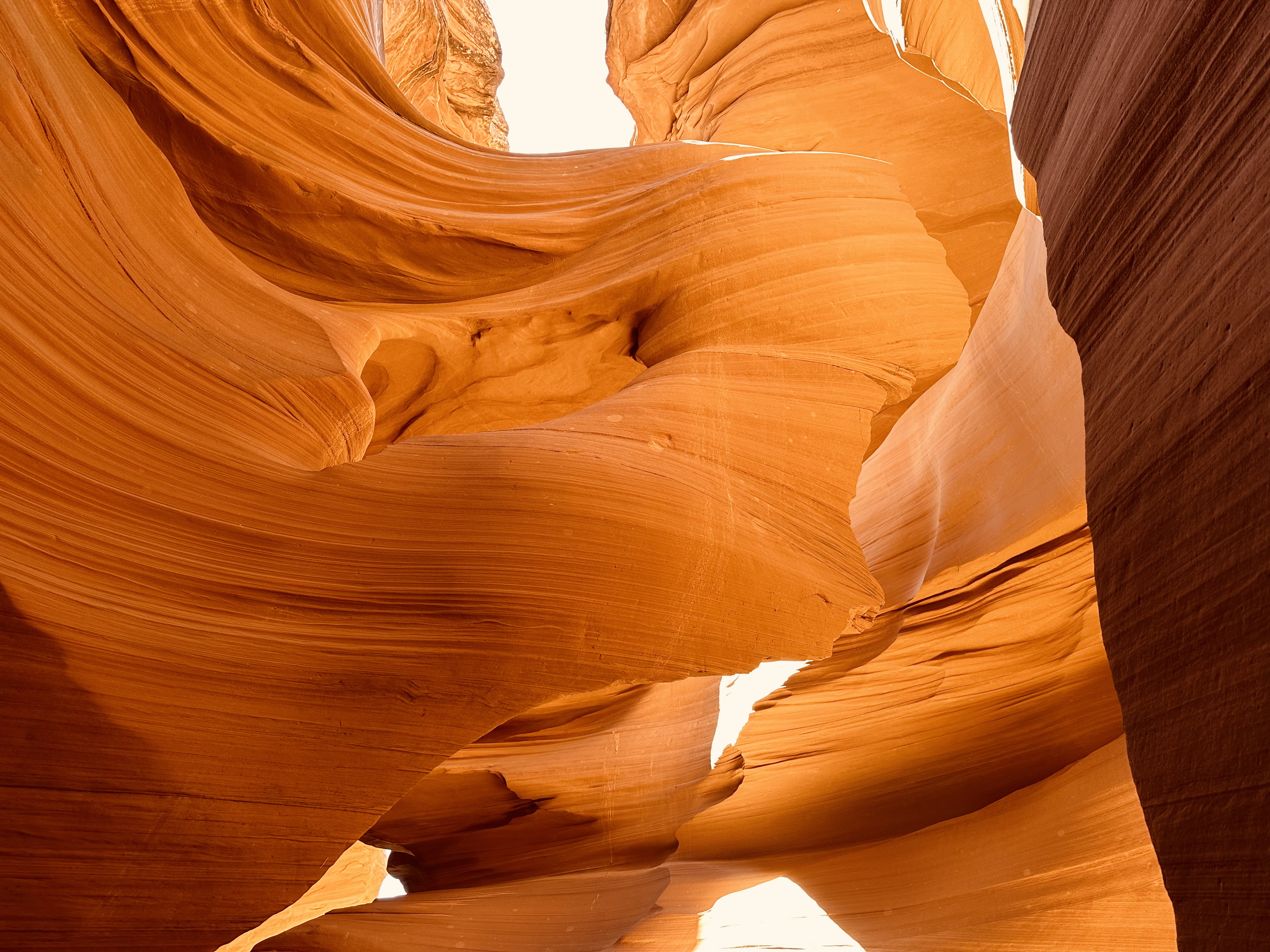
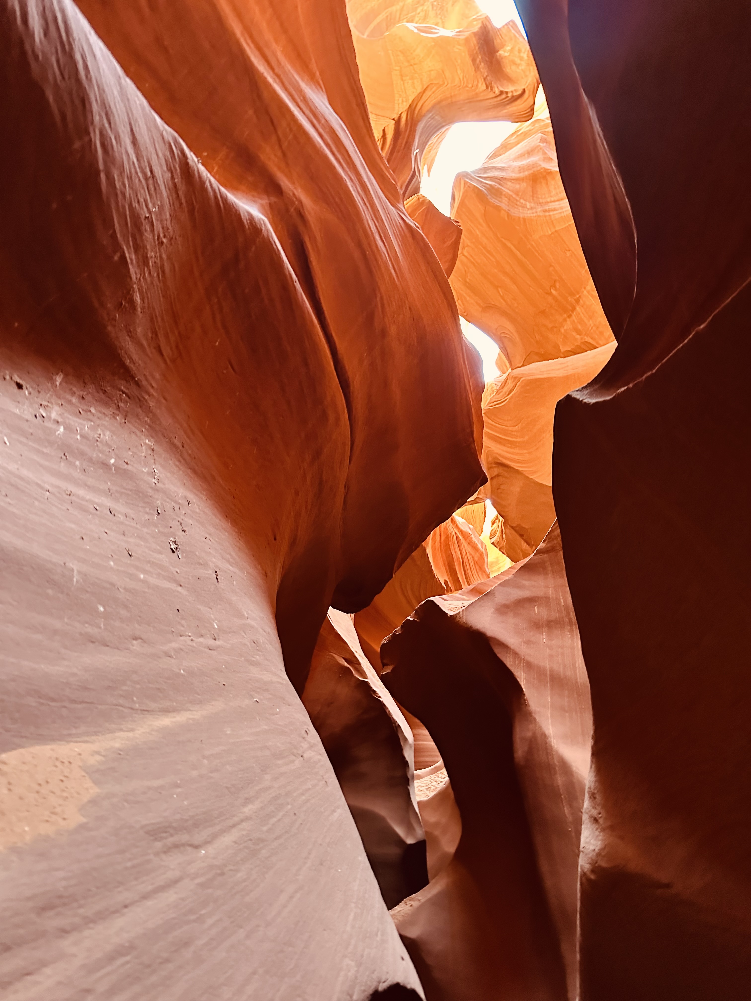
Antelope Canyon is one of the most photographed places around. You see pictures of it in a lot of galleries all over the country and there's a reason why. It's other worldly.
Antelope Canyon consists of six separate slot canyons on the Navaho Reservation. You need to make reservations to experience it and it's worth doing. Upper Antelope Canyon (the one we saw) is only about 660 feet (200m) long but it takes a couple of hours to trek through. There are quite a few ladders and stairs to get down into the slot canyon. The Lower Antelope Canyon is about 1,335 feet (407m) long.
They are formed by water rushing off the land, through the sand stone slot canyons and into Lake Powell. Our guide says they can change with each flood and pointed out a where a very large rock that had been and where it now sits. I can't imagine getting caught in a flood. That would be no bueno.
Tourist Alert: Please do as the guides say. They work really hard to keep the groups separated for a better experience and everyone safe. Some of the ladders are a bit steep and they don't want anyone bailing off of them.
 |
 |
 |
 |
 |
Located about two hours south of us, Tucson's an interesting place to wander around. It's not as "up to date" as Phoenix is. There's something about the vibe there that's not big city.
Robyn and I have headed down to Tucson for a variety of reasons. We've seen a couple of concerts there, there's the Tucson Gem and Mineral Show and if you're any sort of airplane junky a trip to the Pima Air & Space Museum.
|
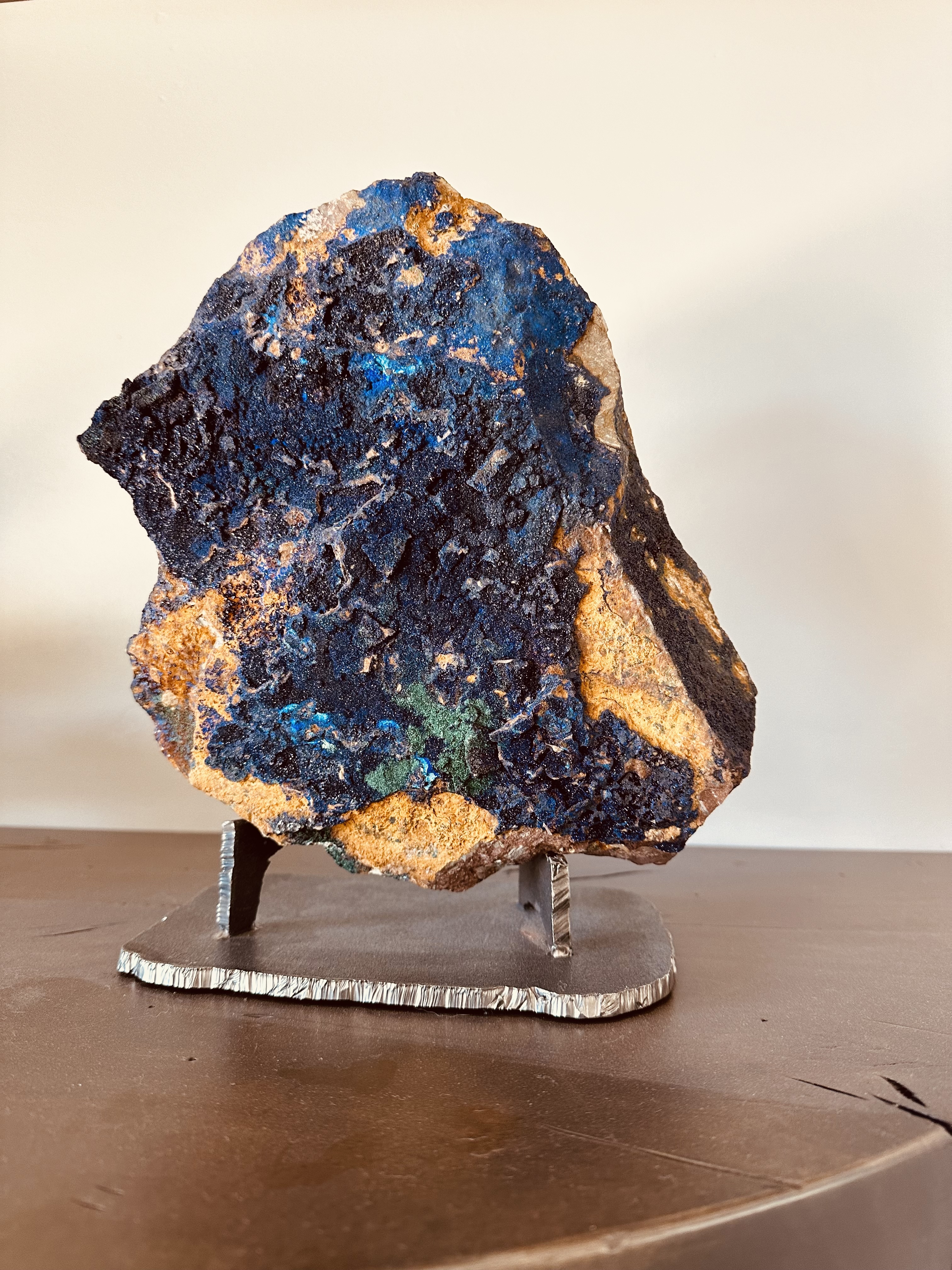
The Tucson Gem and Mineral Show is a hoot. It has darned near everything in the way of gems and minerals. Some of it is dealer only (and I hear that the stuff sold behind closed doors is incredible) but a lot of it is open to the public. The vendors invade a group of hotels along the I-10 corridor and have an incredible amount and variety of gems and minerals on display and for sale. They're fun to bargain with too. Side story to that: Robyn and I had our eye on an egg shaped geode that forms in the mud over millions of years. There's a local place called Rare Earth Gallery just up the road from us (a great place to gawk but keep your wallet tucked away as they'll drain it) and they had one of these. They wanted close to $3,000 for it. Uh, no. I'm not spending 3K on a rock. We also managed to find a really interesting piece that I call 'The Bird' one year. Once again, bargaining was done and we came home with it. I made a stand for it too. |
 |
 |
The Pima Air & Space Museum is a must see if you're interested in aircraft. They have all sorts of aircraft from the beginnings of flight up through WWII (the B-17 display is fascinating) and into modern times. There are hundreds of planes to wander about and look at. Some are inside, some outside. My favorite is the SR-71, which is the fastest air breathing craft to ever grace the skies. It was top secret for years and here sits one that you can wander around and even touch.
I had the pleasure of touring it with a friend of mine who was the Wing Commander at Luke AFB a few years back. He was a walking encyclopedia of knowledge on darned near every craft there and had flown quite a few of them. When I asked him what his favorite one was his response was "All of them. I just love flying." Must have been fun pulling 9G in a F16 or getting to strafe the Iraqi desert in an A-10.
Of course I can't talk about Tucson without mentioning the food. Pull out your phone, use a bit of Google-fu and search. I highly recommend 'Mexican' as a search subject as there are a lot of really good Mexican restaurants. It is only about about fifty miles (80km) from Mexico.
Tourist Alert: The Gem Show only happens during February, which is the prefect month to be here in AZ.
Also, take the time to head just a tad south and check out the San Xavier Del Bac Mission and just to the north there's Mount Lemmon which is one of the higher peaks in this part of Arizona. You'll go from Saguaros and desert floor to pines and mountain views in just a short distance.
|
Saguaro National Park is actually two districts. One about 90 minutes and the other is about two hours from our place. The Tucson Mountain District/Saguaro National Park West which is west of Tucson just a few miles and the Rincon Mountain District/Saguaro National Park East located on the eastern side of Tucson. The Eastern District is about twice the size of the Western District. Both have visitor centers where you can enter. Both districts of Saguaro National Park offer scenic drives around the cactus forest. Each invites new sights and experiences, as well as an incredible number of saguaros. Rincon Mountain District (east): Tucson Mountain District (west): The Loop begins at Hohokam Road, 1.5 miles west of the Red Hills Visitor Center. Leaving the visitor center, turn right onto Kinney Road. Follow Kinney Road 1.6 miles (2.6 km) to the loop’s entrance on the right. The Loop ends where golden Gate Road meets Sandario Road. To return to the visitor center, turn left onto Sandario Road. Continue 0.2 mile to the junction with Kinney Road. Turn left. The visitor center is 2 miles (3.2 km) ahead. Biking is permitted on both the Bajada Loop and Cactus Forest Loop. Keep in mind the difference in terrain between districts, as Cactus Forest (east) is paved, and Bajada (west) is gravel. (these five paragraphs are borrowed from the Saguaro National Park website) Tourist Alert: Keep an eye out for wildlife. There are all sorts of animals, birds and insects to be found in our beautiful desert landscape. Spring is an excellent time to visit the park too. It's not too hot and a lot of the plants, including the Saguaros are in bloom. |
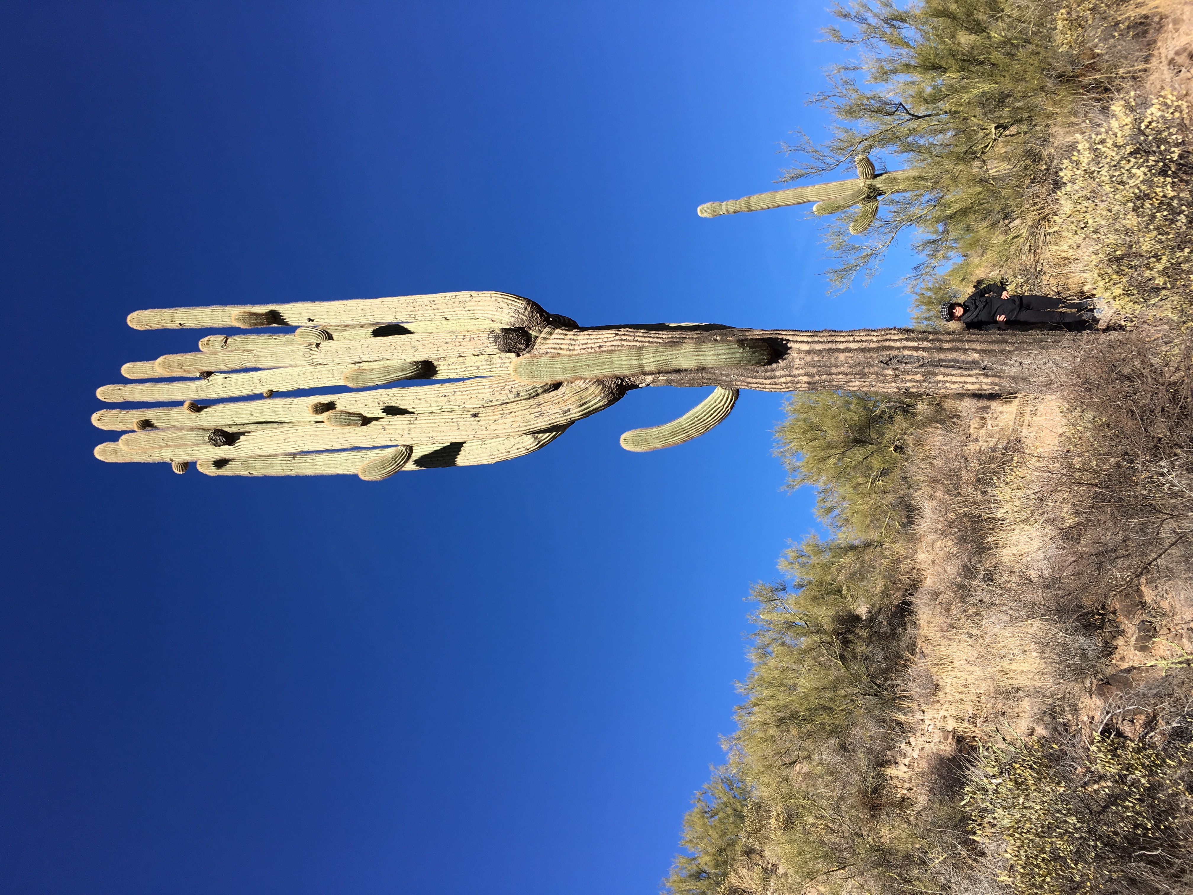 Robyn next to an exceptionally large Saguaro |
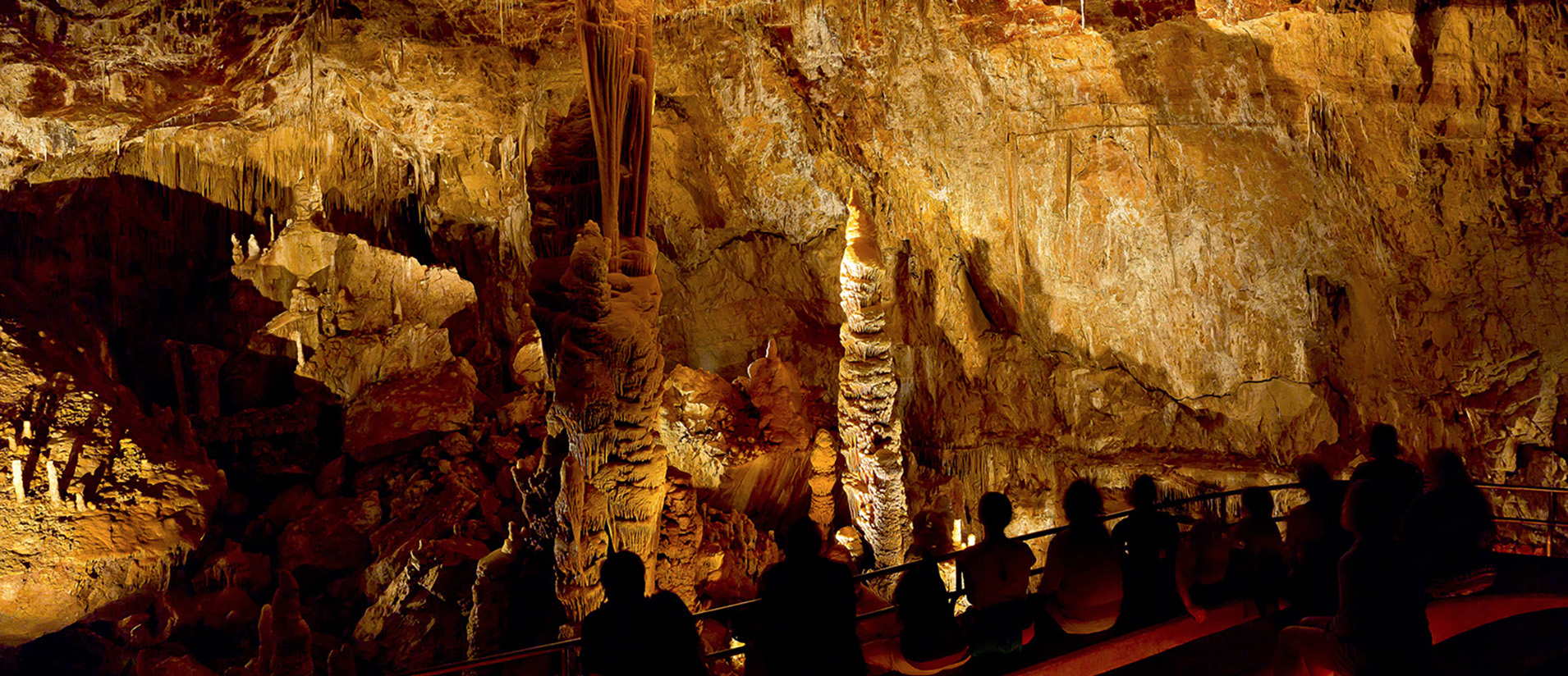
Kartchner Caverns is about three hours away and just under 200 miles (320km) from the R&R. It's well worth the drive and I highly recommend getting a cabin at the state park so you can spend a couple of days exploring the caverns and the land around them. In November 1974, Gary Tenen and Randy Tufts were exploring the limestone hills at the eastern base of the Whetstone Mountains. They were looking “for a cave no one had ever found” and found it. The two kept the cave a secret until February 1978 when they told the property owners, James and Lois Kartchner, about their awesome discovery. Since unprotected caves can be seriously damaged by unregulated use, they knew the cave had to be protected. Tenen and Tufts spent several years looking into the possibility of developing the cave themselves. Some members of the Kartchner family lived in Tucson and were very impressed with the development and operation of Catalina State Park by Arizona State Parks. They decided to approach State Parks to see if the agency was interested in acquiring this outstanding resource. (stolen from the web site) The park has very nice facilities and the cabins are quaint but comfy. |
|
Tourist Alert: I highly recommend going between October 15th and April 15th as the bats are not in the Big Room so you can go into it. The difference between it and the Rotunda/Throne rooms is drastic. Hard to believe both of these caverns are under the same mountain.
Kartchner Caverns State Park also has the International Dark Sky Park Designation so the skies are amazing at night if there are no clouds or moon light.
I can't say much about Tombstone other than I've driven through it a couple of times and filled the truck there once.
The infamous O.K. Corral, where the Earps and the Clanton-McLaury gang had a famous thirty second shoot out, resides in Tombstone and they have a recreation of the incident that they play out on a daily basis for the tourist that come to the Wild West.
I hear it's quite entertaining to see and I guess if you're a fan of the movie Young Guns this is a destination spot.
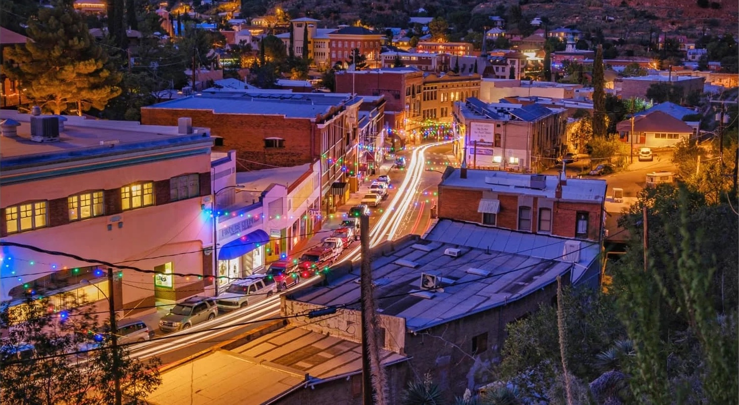
| Bisbee is another old mining town that was extremely prosperous at the turn of the 20th century. It has history that's quite similar to Jerome and is situated about two hundred miles from the R&R. Plan on a drive of about three and a half hours to get there.
Bisbee has a lot to take in. I highly recommend going to the Bisbee Restoration Museum as the history of the little town is fascinating. One example is that Bisbee had electricity running through out the town before places like New York City and street cars before San Francisco did as they supplied a vast amount of copper to the country from the mines that surround the town. In fact, there are approximately 2,200 miles (3,542km) of workings under the mountains between Bisbee and Douglas, AZ. Speaking of Mines, make sure you take in the Copper Queen Mine Tour or maybe an After Dark Ghost Tour or get in a Jeep Tour while you're there. The landscape is, like the rest of Arizona, really pretty. Bisbee has a lot of places to stay. Considering it's size, there are quite a few places from rather humble on up to quite nice. There's a trailer park hotel that consists of older RVs and travel trailers that looks like an absolute hoot to stay in. I can't find a link to it unfortunately. There are also quite a few restaurants in town where just about anyone will be able to find the food they like. Tourist Alert: We found Bisbee to be really fun. We need to get back and explore it more. I'm not sure when "season" is but I think it's probably best to go then (winter). When we went the town was pretty quiet. Especially since we like to go on week days and avoid the crowds. |
|
|
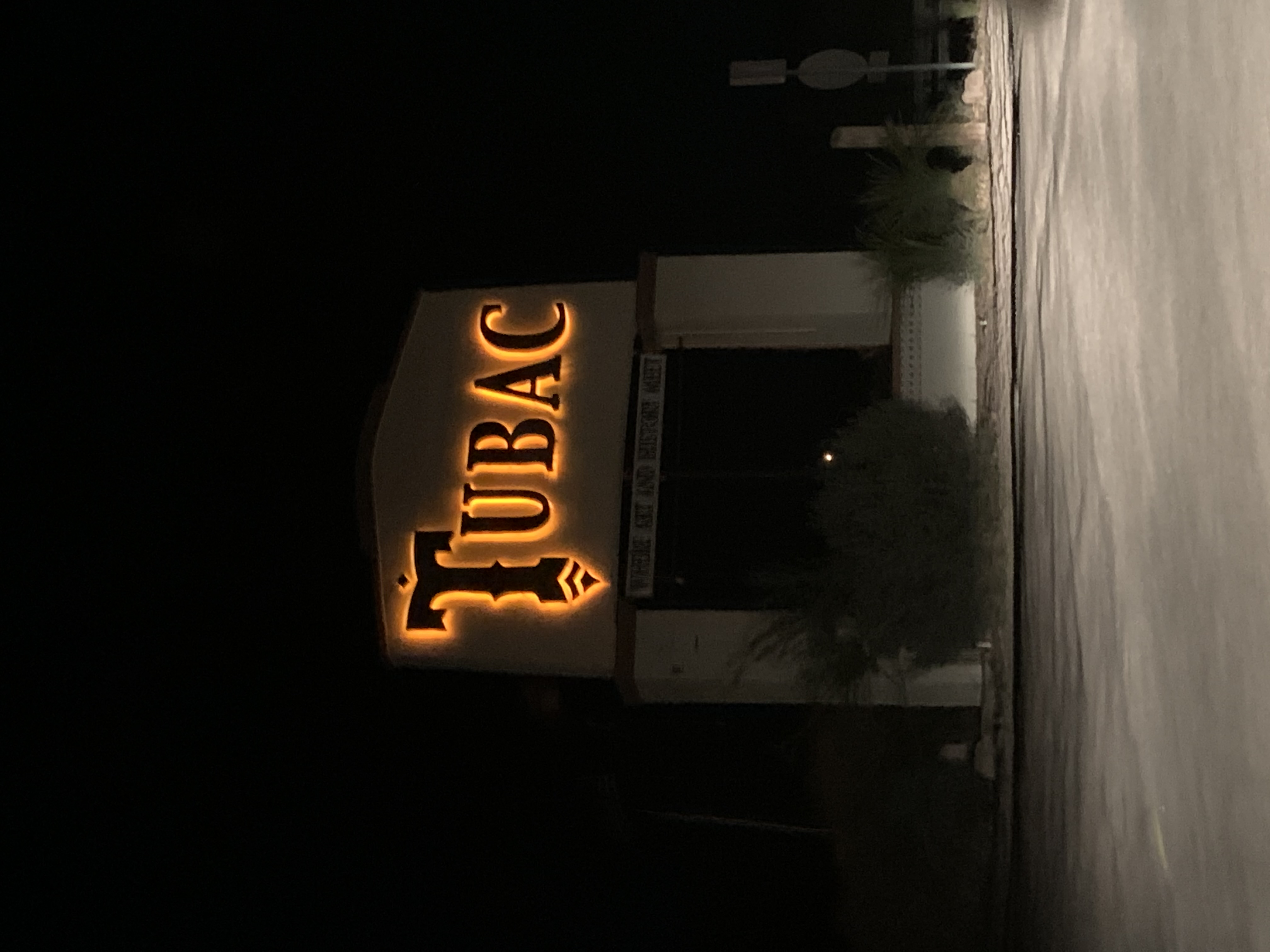
Tubac is one of our favorite destinations as it's a place to just go, sit back, chill and watch the world go by from. It's about 150 miles (240km) from our place. Takes about two and a half hours to get there. It's a direct drive down I-10 until you get to Tucson, then just hang right on I-19 and head south another forty five minutes. Stop in Green Valley and stock up on supplies, as it has pretty much everything you need there. Tumacácori National Historic Park is well worth visiting. It's one of the two oldest missions in Arizona, dating back to 1691 by Padre Eusebio Kino. San Xavier Del Bac Mission, which is about 35 miles (55km) north it the other one. We've visited both and found them quite interesting. Definitely old and historic. Being that we camp with a toy hauler, we always stay at the De Anza RV Resort which is just a couple of miles north of Tubac. It's a really clean, well laid out, pet friendly place. It also has access to a lot of off roading, like venturing to Patagonia for pizza at the Velvet Elvis as La Mision (plan on an all day drive and make sure you have the correct trail marked - ask us how we know...). You'll go past the Fred Lawrence Whipple Observatory. As we understand, the observatory is open to the public once again. It was not when we were there in February of '23. I'd like to go see what we can see there. Tubac is an artisan town. The town's plaza also has a lot of art galleries and a few restaurants too. We've headed to Tubac during the art festival in February and have enjoyed the sights, sounds and food. In the plaza, towards the back at the corner of Cam Otero and Burruel Street is Soto's Outpost Mexican Restaurant. They have a mariachi band that's a lot of fun. Ask them to play some Elvis or even some modern song. They have a blast converting them to Mariachi style and do it quite well. |
The art work that you'll find in the plaza is beautiful and there's something for every taste.
If you enjoy cooking, you should head to the Santa Cruz Chili & Spice Shop on the south end of town. The smell when you walk in is delicious and they have all sorts of Mexican spices along with the normal ones too. We actually need to go back and restock.
Speaking of food, if you like Mexican, Wisdom's Cafe is some of the best I've had in Arizona. (still doesn't match South Texas Mexican food. Nothing does and man I miss it.)
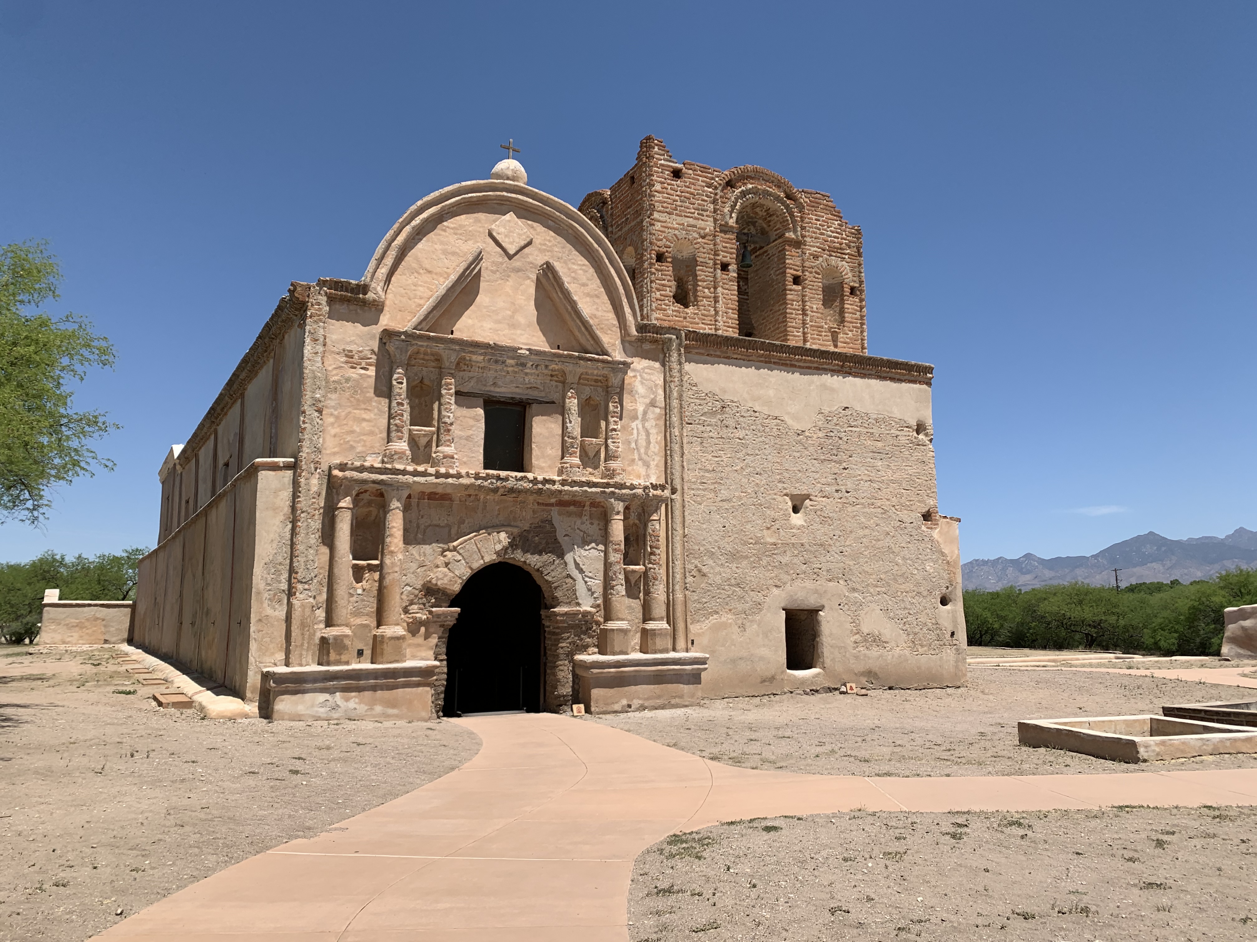 Tumácacori |
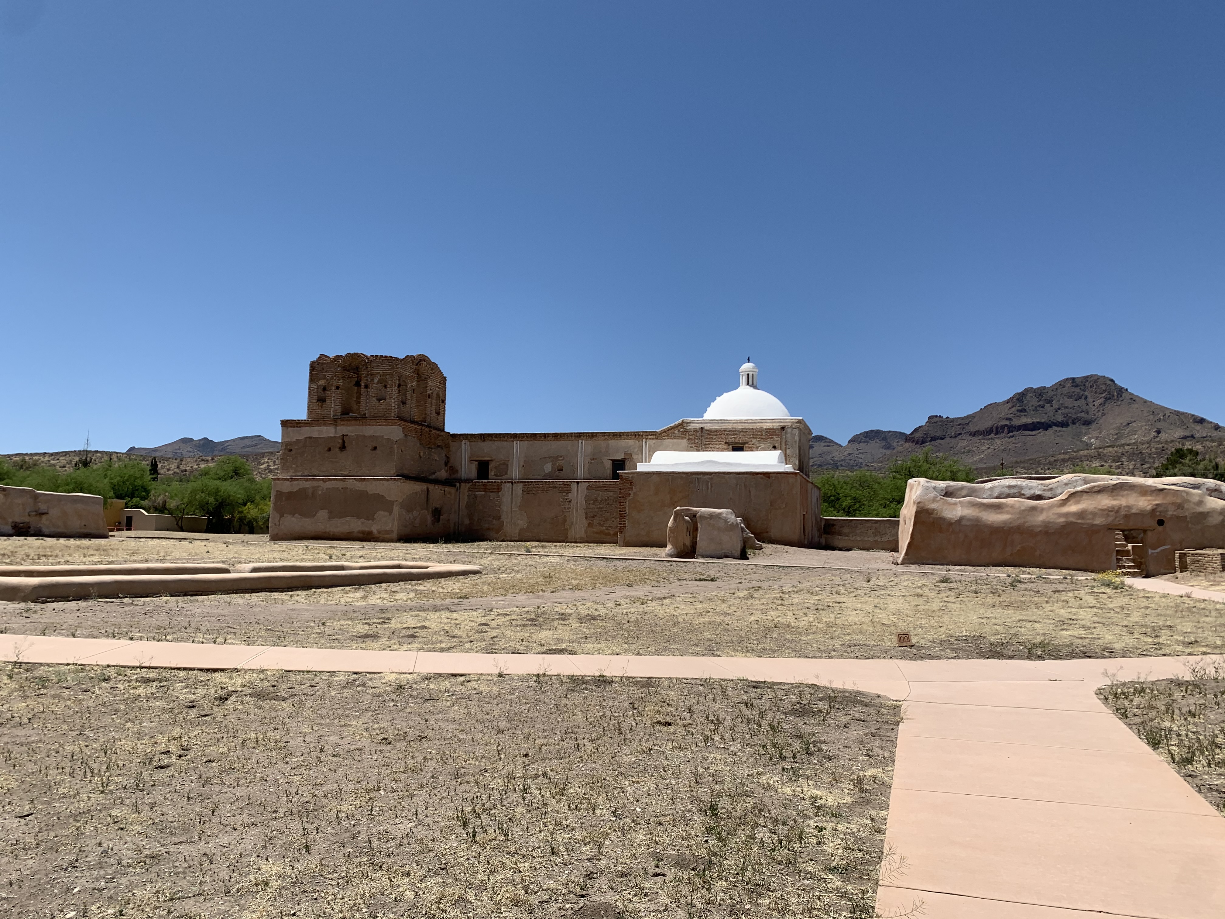 Tumacácori |
 Fred Lawrence Whipple Observatory |
 On the road to Patagonia |
Tourist Alert: Take notice: As soon as you get onto I-19 the speed limits, distance signs and mile markers are all metric as it's one of the main highways from Mexico into the Untied States starting at Nogales.
Also, when you go through the border patrol check point, just act normal. Don't get all spooked, just answer any questions they may have and be on your way. Most of the time they just give you a glance and wave you on through.
Relive 'Patagonia to Tubac'
|
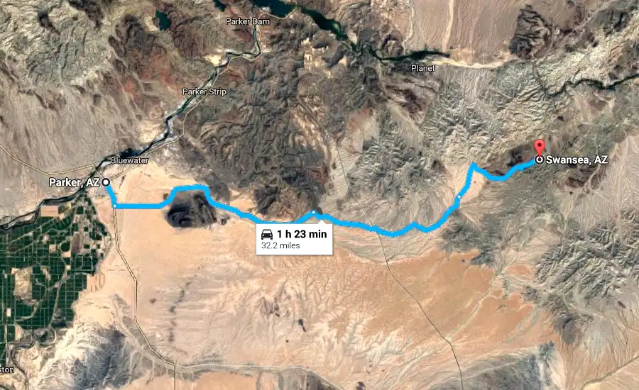
Parker is situated on the Arizona California border on the Colorado River and it is definitely a snowbird destination. I get the feeling the town dries up when they head back north away from the heat. Parker gets HOT in the summer. Temps above 115F/46C are not uncommon June through August. That whole strip along the Colorado River from north of Lake Havasu on down gets "Africa hot". (points if you know where that reference is from) It takes us about three hours to travel the 166 miles (267km) to get there. You can take I-10 out of Phoenix but since I truly despise I-10, I recommend taking the Carefree Highway (SR-74) to Wickenburg (about an hour's drive) finding US-60 and enjoying the scenery. When you get to Hope, AZ, look for AZ-72 (which turns into AZ-95) on the right and head down that on into Parker. While it's only two lanes, the traffic is light and there's so much more of an "Americana" feel to it. This route only adds about fifteen minutes to the trip and the lack of I-10 stress is well worth it. We've made it a bit of a tradition to stop at Ruperto's Mexican Food, a little shack of a place on the left one block after turning right onto Riverside Drive by the Terrible Herbst Convenience store. This is pretty much the main intersection in town after you enter it. There's also the Tierra Caliente Meat Market on South Joshua Ave and W 9th Street. You can get cabrito there! YUMMY STUFF! This is truly an authentic Mexican market. If you're not familiar, give it a look and get some cultural education. BTW, cabrito is goat and if prepared correctly it's delicioso. Muy Bien! Parker is a little river based town retirement village. There are bars and cafes all along the water. You can rent jetskis and boats and enjoy the Colorado. There's also the par three . The Parker Dam is fun to take a quick trip over too. Built between 1934 and 1938 by the Bureau of Reclamation, it is 320 feet (98 m) high, 235 feet (72 m) of which are below the riverbed (the deep excavation was necessary in order to reach the bedrock on which the foundation of the dam was built), making it the deepest dam in the world. The portion of the dam above the foundation stands 85 feet (25.9 m) tall, making it the only dam in the world that stands more underground than above ground. (the dam info is stolen from Wikipedia) |
|
Parker has three state parks: Buckskin State Park, Cattail Cove and River Island. We've stayed at Buckskin many times and thoroughly enjoy the place. It's neat, tidy and the river loops around it nicely. There are a lot of hiking trails surrounding it and off roading is just up the road. Once again, look for a big chicken on the right and head in there. Not sure what it is about Arizona and big fiberglass chickens marking stuff.
I can't say anything about River Island, as we've not been there. We scoped Cattail Cove out last time we were in Parker and made reservations for there the next time we venture towards the western edge of Arizona. It's a bit farther north of town than Buckskin is.
Tourist Alert: Parker holds one of the more famous desert races - The Parker 400 in January. (I never got to race this one),
|
The Desert Bar, Nellie E Desert Bar, Nellie's - I've heard it called all of these - is a destination. If you're not off roading, you can turn off of 95 on Cienega Springs road and get there with your car. It's about five miles of dirt road. If you're off roading, there's a few ways to get there. As mentioned before, we head north on 95 until we see the River Island Market. The chicken I mentioned sits on top of the canopy over the gas pumps. Stop in, grab some water and then head off down the trail. We discovered the Desert Bar completely on accident. We'd decided to go off roading and were told to go to the chicken and then head right into the mountains. The terrain is really rugged. I'd not try going in unless I had a vehicle set up for off roading. It's about ten miles (16km) of dirt road to the Desert Bar. It goes past a few abandoned copper mines and the mountains surrounding the area make for some really pretty landscape. As I was saying, we found the Desert Bar accidentally. We're out off roading following what is a pretty well defined trail and as we come over a rise there's what looks like a small town sitting in the middle of nowhere. We ventured on to the place and found a little desert treasure. It's only open October through April. They have live bands, three eating facilities, and a couple of dance floors. It's built on the site of an old mining camp named after the mining claim, "Nellie E". |

|
|
Mountain View |
We didn't think these were real until they moved |
One of the mine entrances |
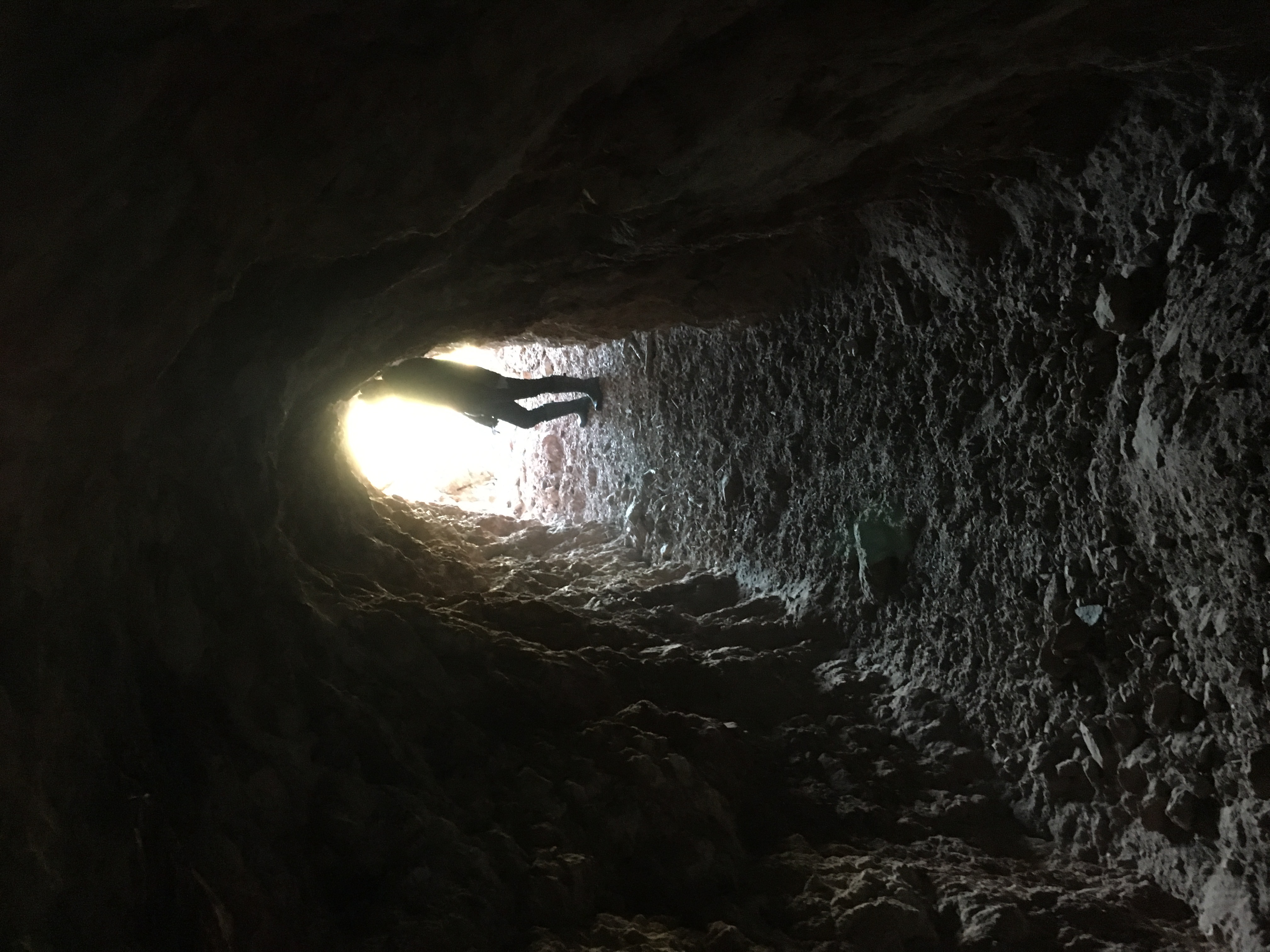
Looking out of the mine |
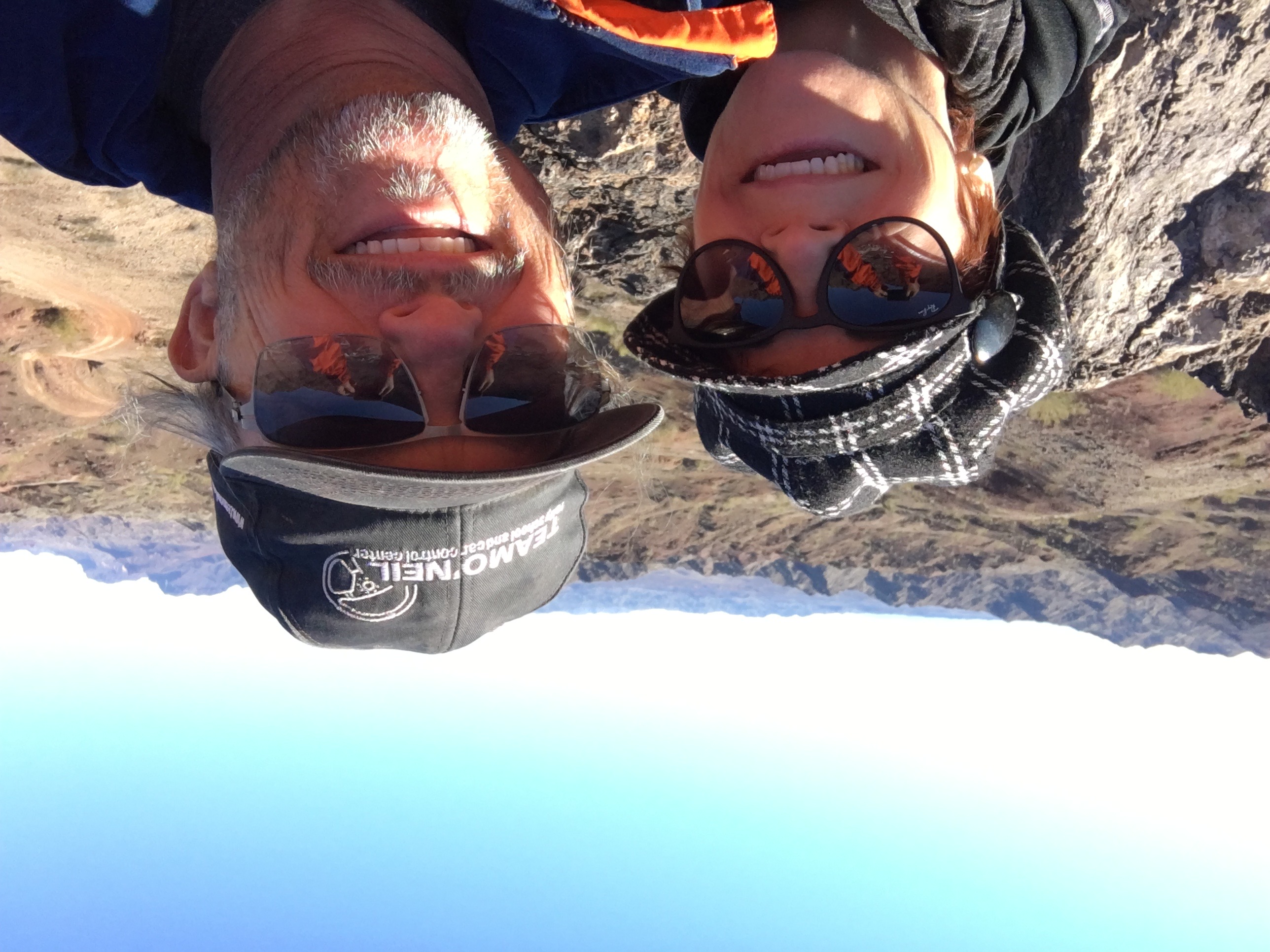
Happy Campers! |
|
Tourist Alert: Don't go near Nellie's property during off season. They're NOT nice about it. We just stopped to ask the guy a few questions and he was really quick to chase us off. When they say they're open October through April, they mean it. Also, don't ask for cheese at the grill right inside the back entry. |
 |
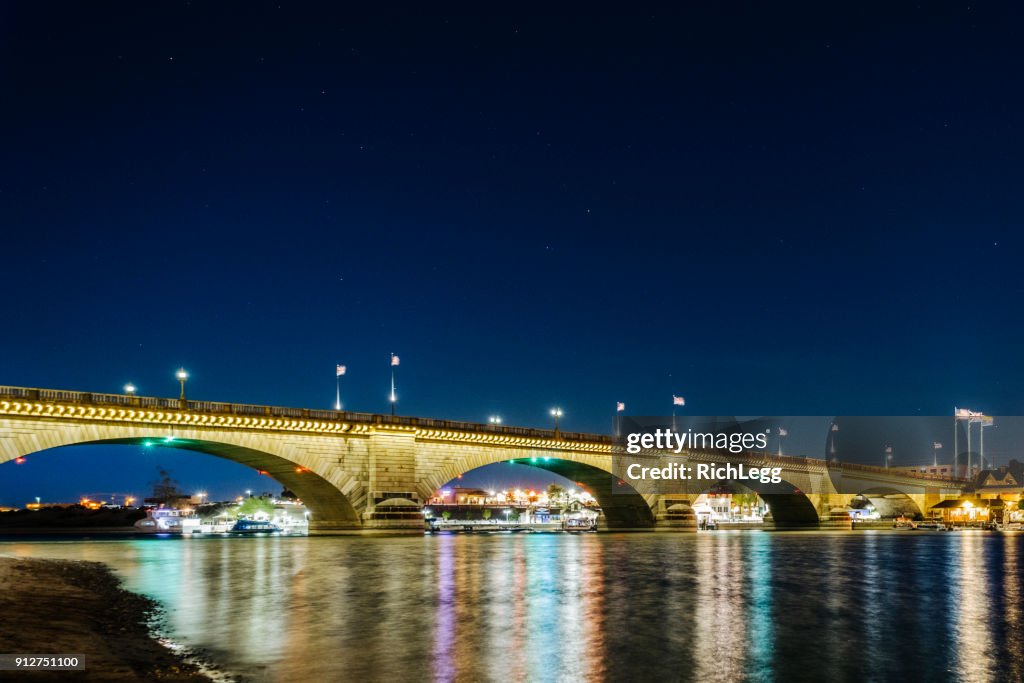
Havasu sits at the base of Lake Havasu and it's claim to fame is the London Bridge. Havasu is about a forty five minute drive north of Parker on 95, more or less following the Colorado River. You can get there off road if you're up for an adventure. One can find everything "recreational" in Havasu. The lake is large and pretty. It has some spectacular rock formations along the banks. There are beaches where one can swim, boating, watersports, fishing, golfing, hiking, off-roading and cycling. (I stole this info from the Havasu web site). There's a shopping/eating/tourist area at the base of the bridge and we usually hit Papa Leone's Pizza when we did our annual Jet Ski trip years ago. They make good stuff there. Actually, there are good restaurants on both sides of the bridge. We also enjoy Angelina's Italian Kitchen when in Havasu. Take a look at the comical stuff outside of Camel Towing right next door. Tourist Alert: If you're really up for an adventure, start out REALLY early in the morning, rent a PWC and take a 65 mile trek up the Colorado to Laughlin/Bullhead City. It's an all day affair. We used to do it from Laughlin/Bullhead City, down to Havasu, eat pizza at the base of the London Bridge and then head back up to Laughlin. Talk about FUN! Also, stop at the Human Bean on the way back to Parker and snag some coffee. Just be warned they serve it HOT, HOT, HOT! It's at the last intersection just before you leave Parker on 90 at the corner of McCulloch. |
 |
|
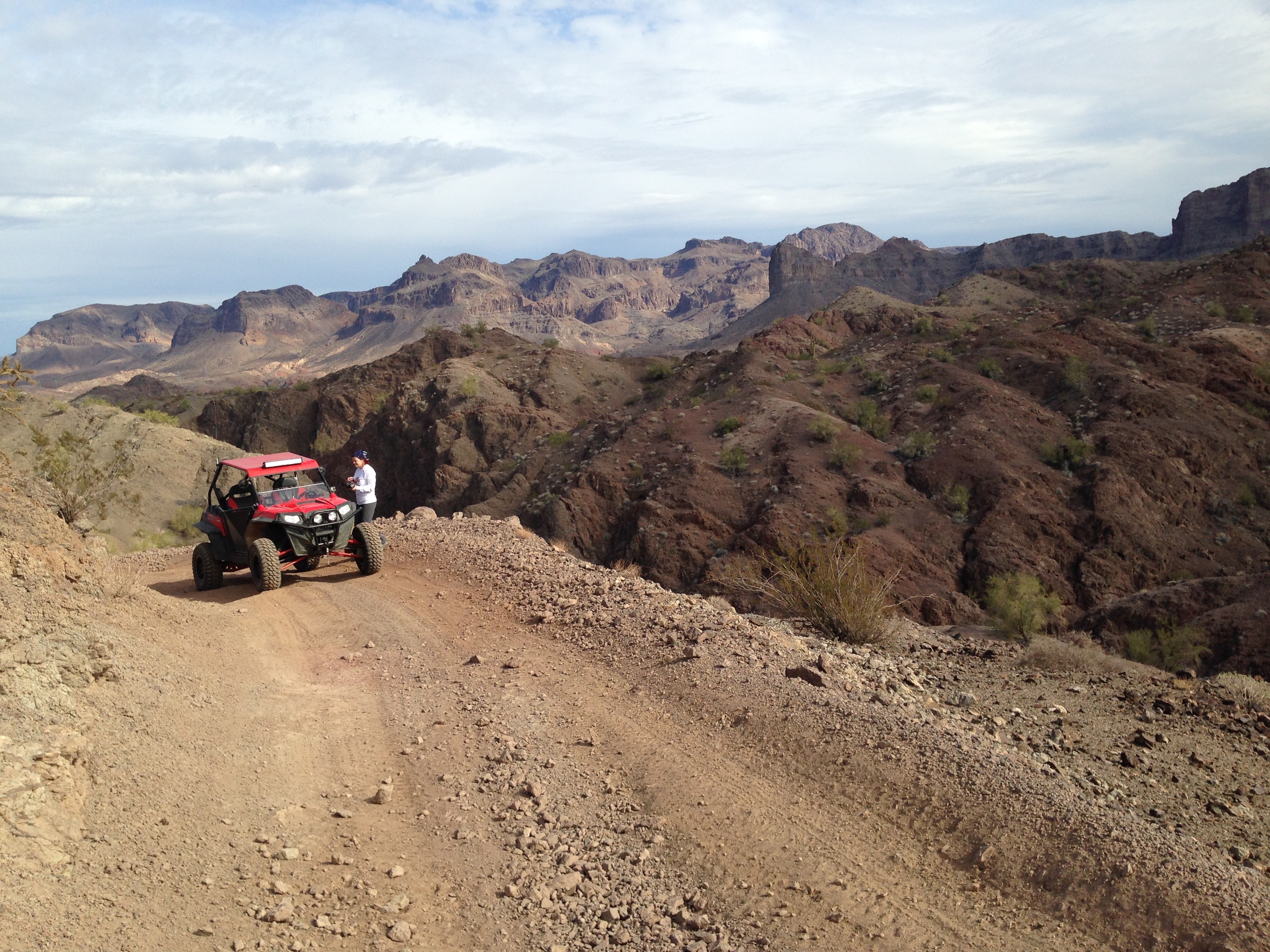
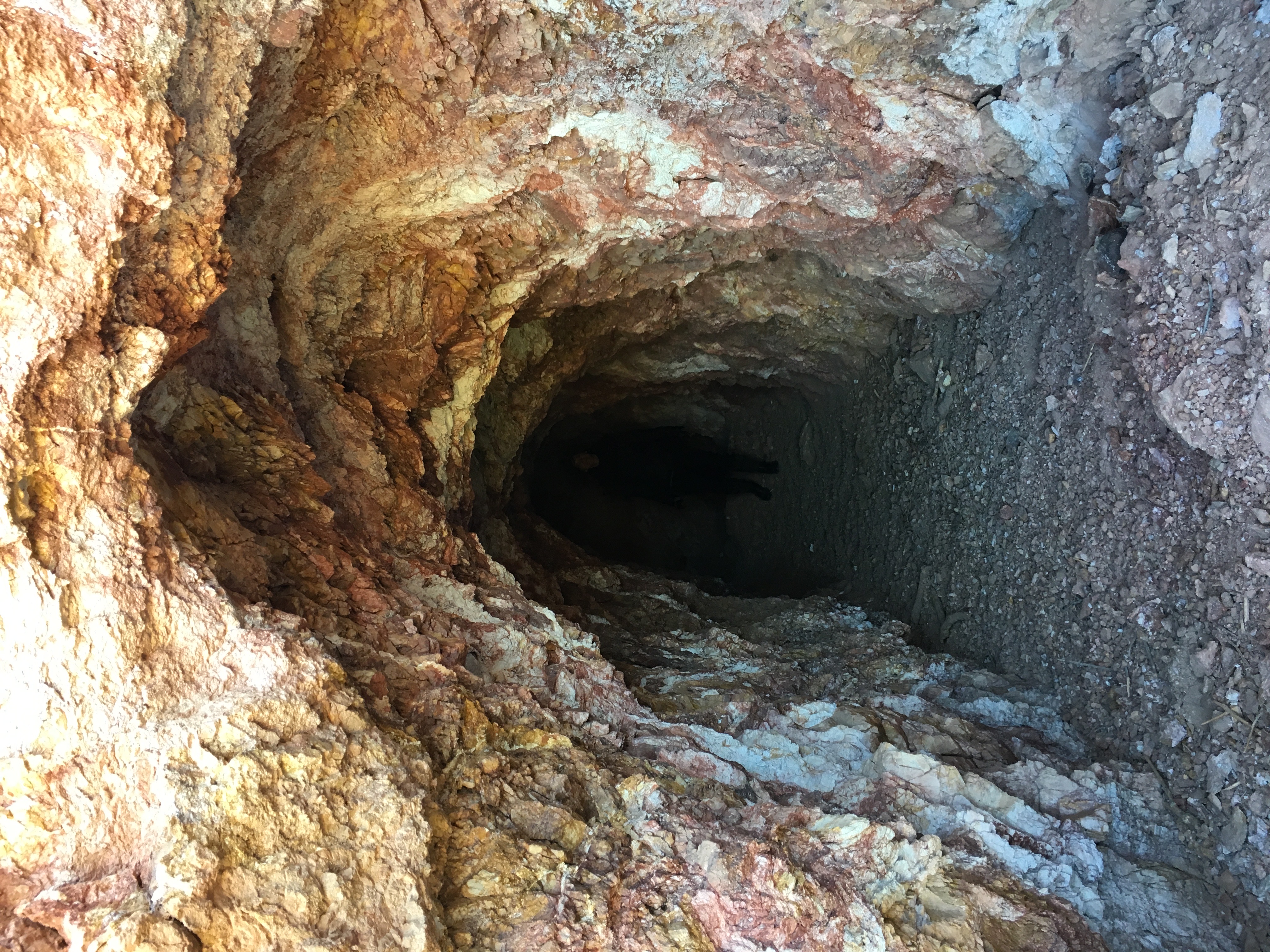
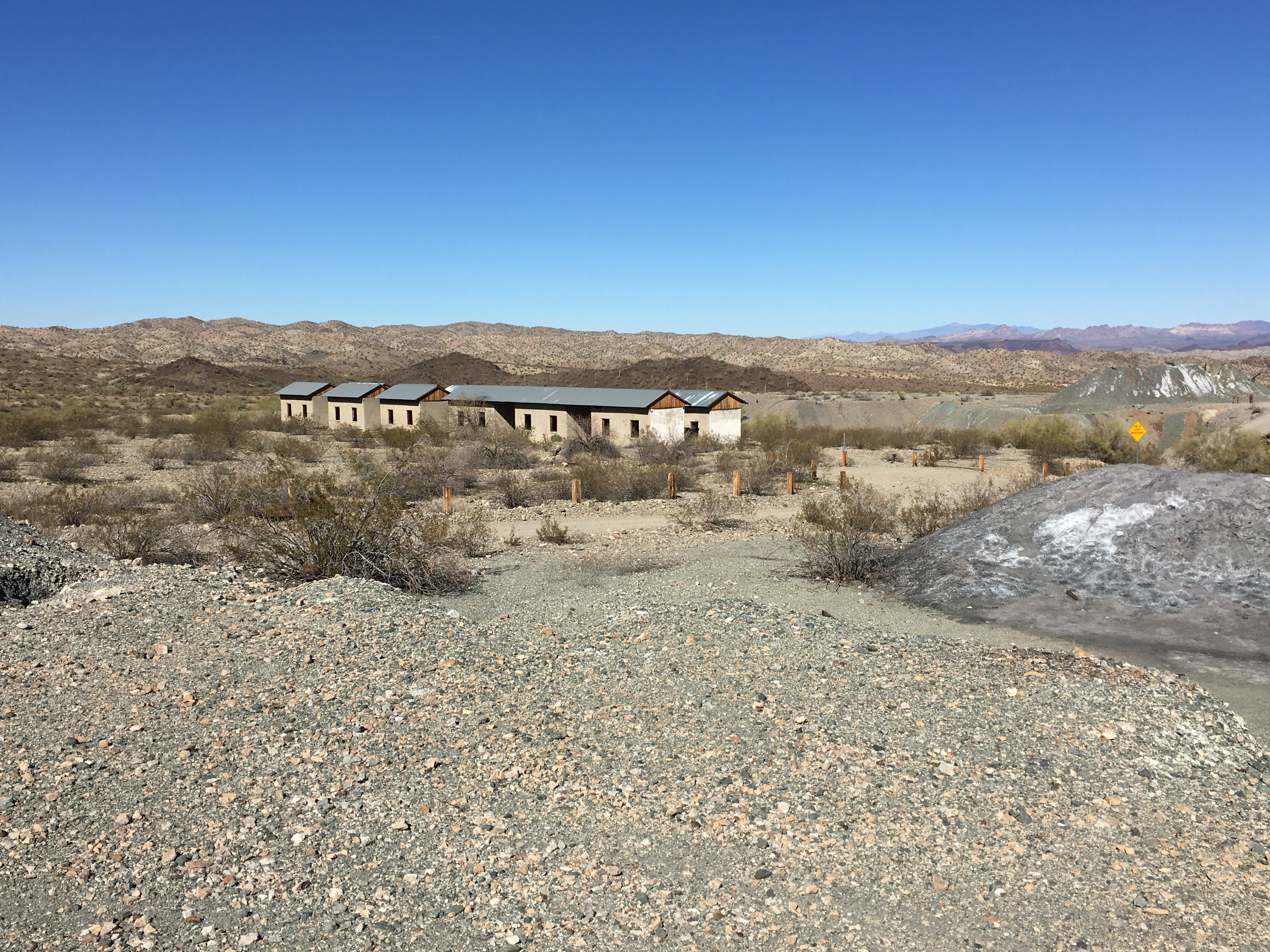
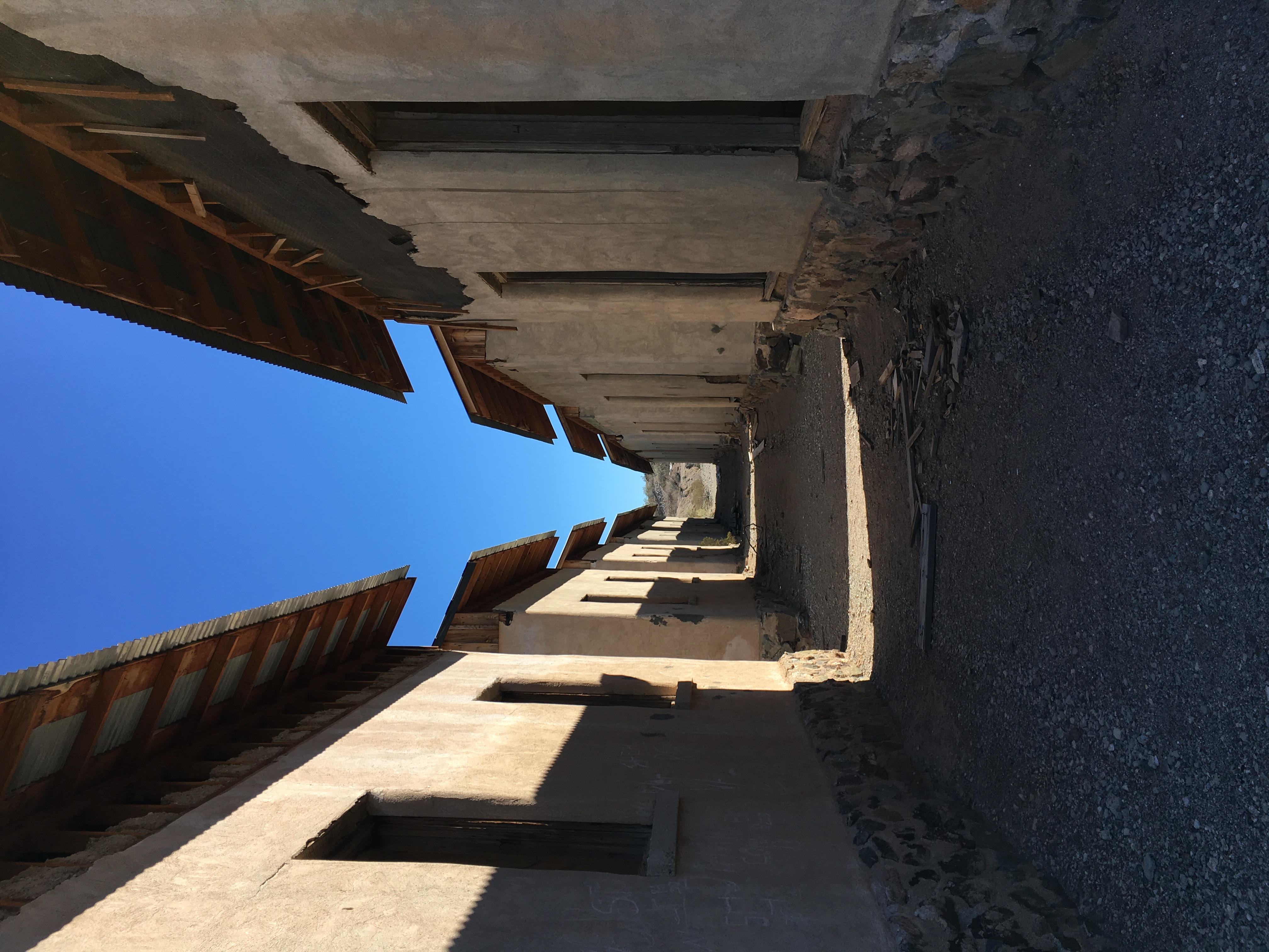
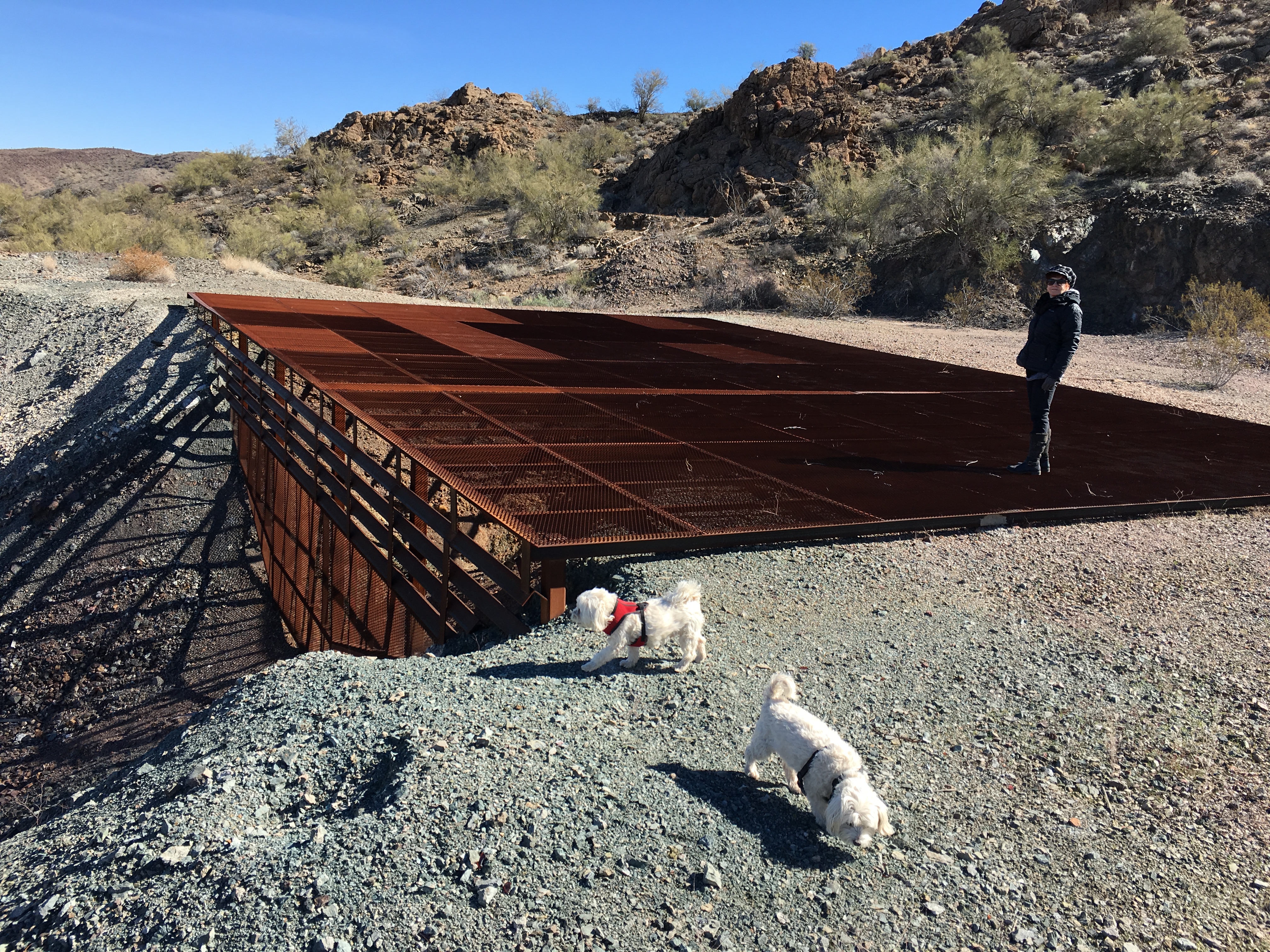
The Swansea Mine is very interesting. You can get there in a car but it'll be a really rough ride, especially the last four or five miles. An off road vehicle or pickup truck will do just fine but once again, expect it to be rough. We always go in our UTV - and that last few miles is still rough... Swansea was settled in 1909 as both a mining and smelting town where they pulled copper out of the ground and then processed it for shipping. There are quite a few of the original structure foundations still present and some of the living quarters are still in surprisingly good shape considering the place was abandoned in 1937. The off roading around Swansea is pretty good too. There's a canyon to the north east that has some really pretty slots and an area where the water has polished the rocks into large, smooth ridges. The power to cut the granite like it has is immense and you'll be surprised at how smooth it's polished the mountain as you stand there in the ridges. |
 |
Tourist Alert: Swansea is out in the middle of absolutely nowhere. Make sure you have a full tank of fuel and a cooler full of drinks and snacks. The traffic is a trickle, to say the least. Be prepared. Also, as like the majority of the state, Summer just isn't the time to be here. Like Nellie's, October through April are the prime months to visit.
 |
 |
 |
|
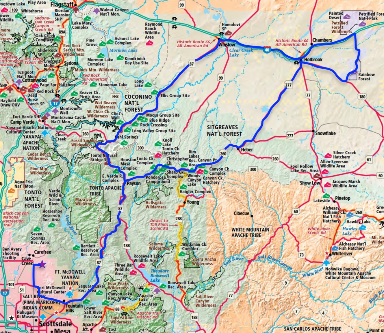
Winslow, Holbrook, Painted Desert, Petrified Forest
I recommend heading up AZ-87 out of Fountain Hills to Payson (do NOT eat at the Mexican place at the corner of AZ-87 and AZ-260!) and then turning at AZ-260 and heading towards Heber. You'll drive along the Mogollon Rim (pronounced "Moe-Gee-Yawn") in the pines. Once again, beautiful country with spectacular views. Once you get to Heber, turn left on AZ-377 and head to Holbrook. From there you can take US-180 east to the entrance of the Rainbow Forest, which is the lower end of the Painted Desert and Petrified Forest National Parks. The tour will take you north and you can leave via I-40. Follow I-40 west to Winslow and stop at any of the many corners, play a song and take a picture. Both Holbrook and Winslow are on Historic Route 66 and it's like driving through the past and pure Americana. Once you've seen the sights, head west on I-40 towards Flagstaff and stop off at the aforementioned Meteor Crater.
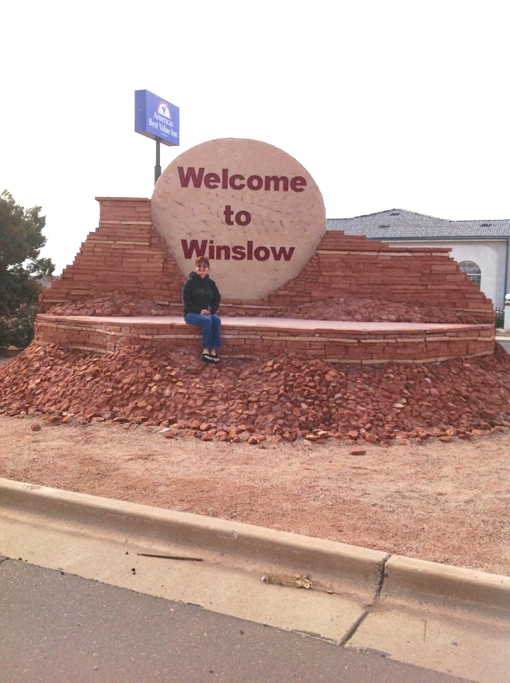 Sitting on a Corner |
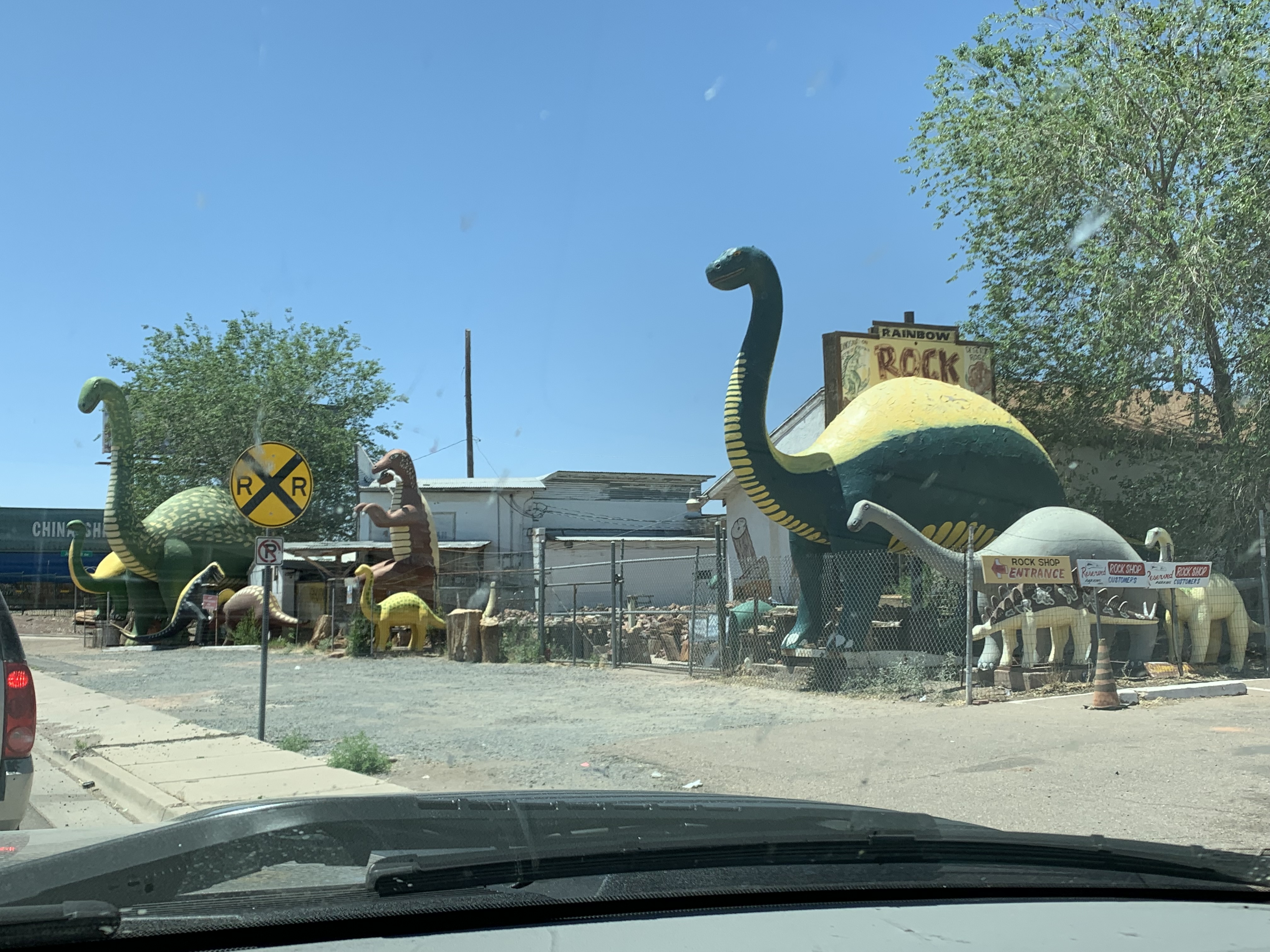 Want a Dinosaur? Holbrook has 'em |
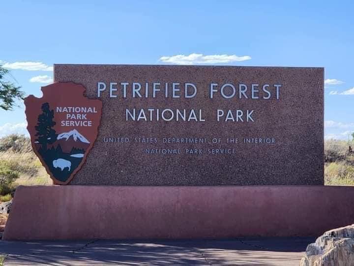 Welcome to the Petrified Forest |
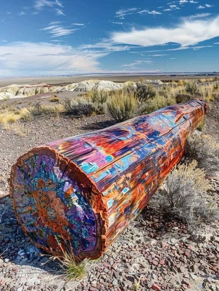 Just one of the amazing trees |
Tourist Alert: This could probably be a day trip from the R&R but making it a stay over in either Holbrook or Winslow would probably make it more fun. Holbrook is 180 miles (290km) and a bit over three hours if you take the route through Payson and it's 224 miles (360km), but about the same time to come back via I-40/I-17. You can throw in the Meteor Crater as part of a loop to boot.
Kanab is another one of our favorite places to just get away. It's about 230 miles (370km) and a bit over five hours of seat time to get there. It sits at the intersection of US-89A and US-89. It's an old town (for the area) and has a lot of history hiding in it. It was the site of many western movies from the 50s and 60s and still really has that feel to it.
We usually stay at the Anasazi Village Mobile Park which is a block south of where 89 and 89A meet. It's convenient to pretty much everything (the town's not that big). If you have a bicycle, you can get just about anywhere in town in ten to fifteen minutes. One of our favorite breakfast spots is Houstons's Trails End Restaurant.
Kanab is situated well as a hub to explore from. Bryce Canyon, Utah is just up the road about 90 miles (145km) which takes about ninety minutes. I think Bryce is prettier than the Grand Canyon. Zion National Park, Utah is another ninety minutes up the road from Bryce Canyon. You can tie the two together as a day trip and it's a fantastic way to spend an afternoon.
There's a lot of adventuring to do from Kanab. We've enjoyed going off roading and would like to explore more. There are UTV and Jeep friendly trails all around. Stop in the town's welcome center and snag more info if you're interested.
Head on north just a bit more and look for the Moqui Cave on the right. It's a museum that started out as a compound for the man who built it. It's quite worth stopping in and experiencing. The man behind it was a Mormon and boy did he practice his religion. Lots of kids... The museum inside has a lot of interesting things on display. It's a good way to spend and hour or so killing time.
We've had a variety of food in Kanab. We like going to the strip along 89 across from the Shell station and seeing what the local diners have. There was an excellent Mexican place just down the street from the RV park we stay in. Sometime's it's open, sometimes not.
The Sand Caves, just north of Kanab on US-89.
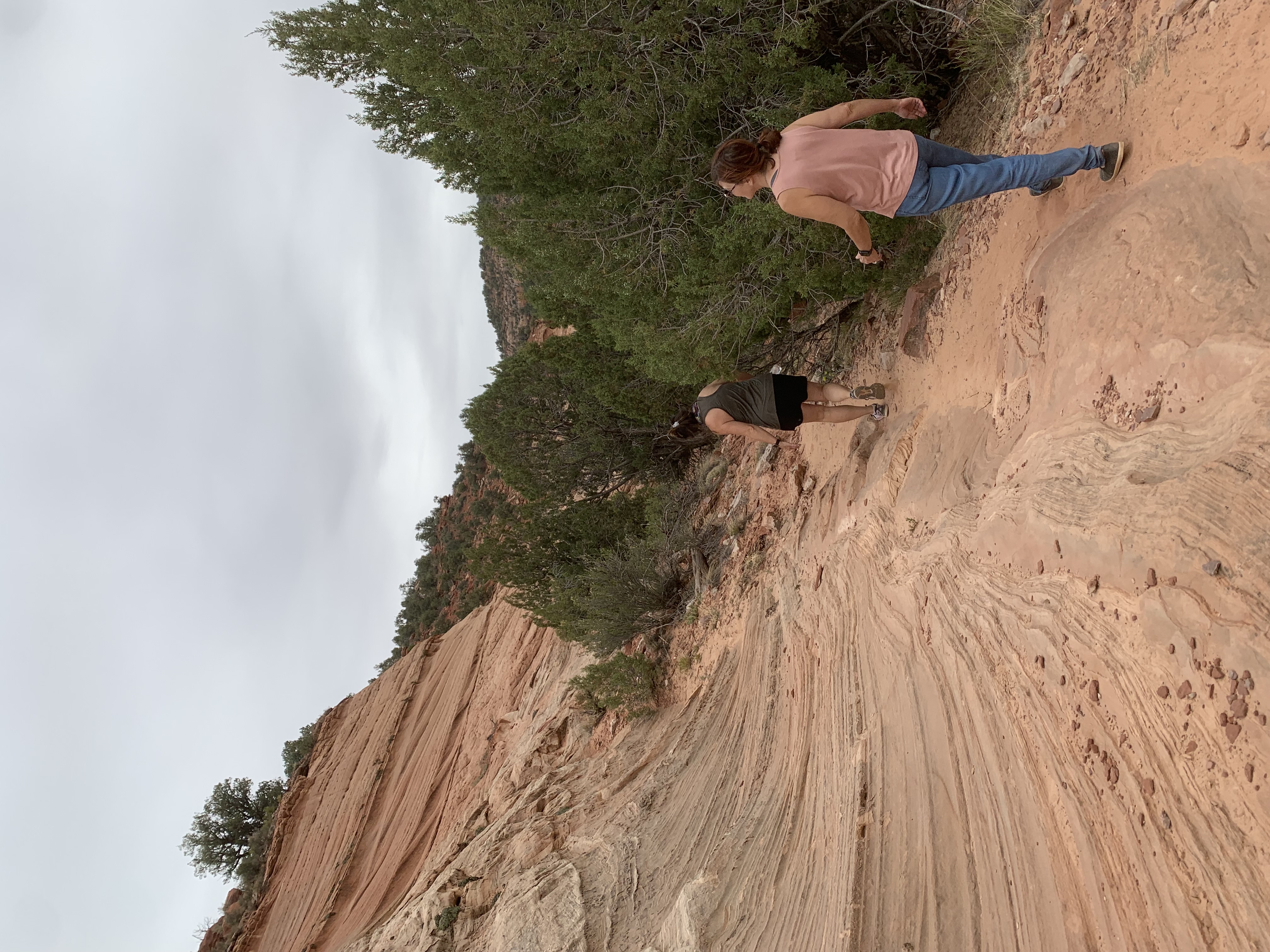 | 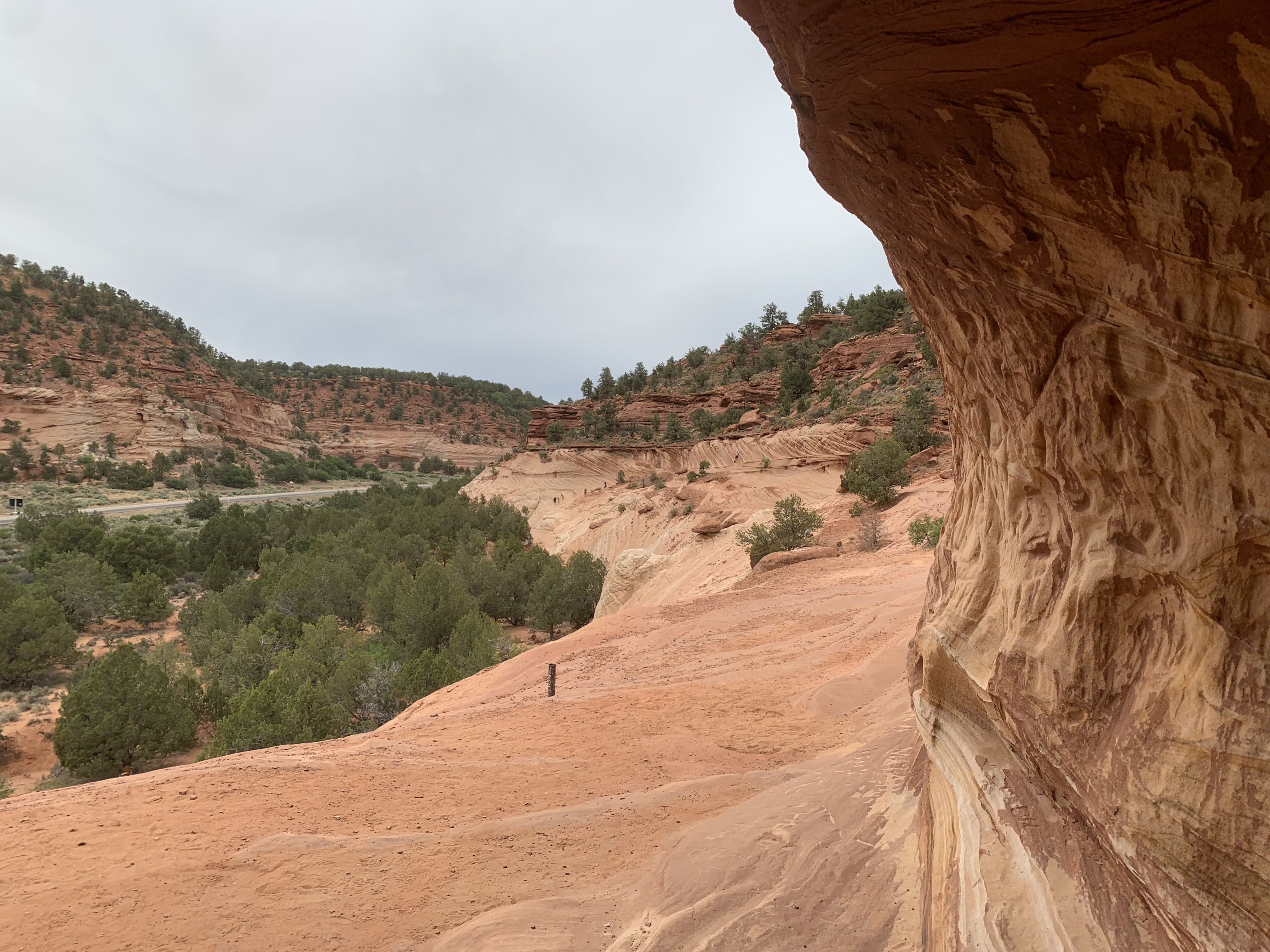 | 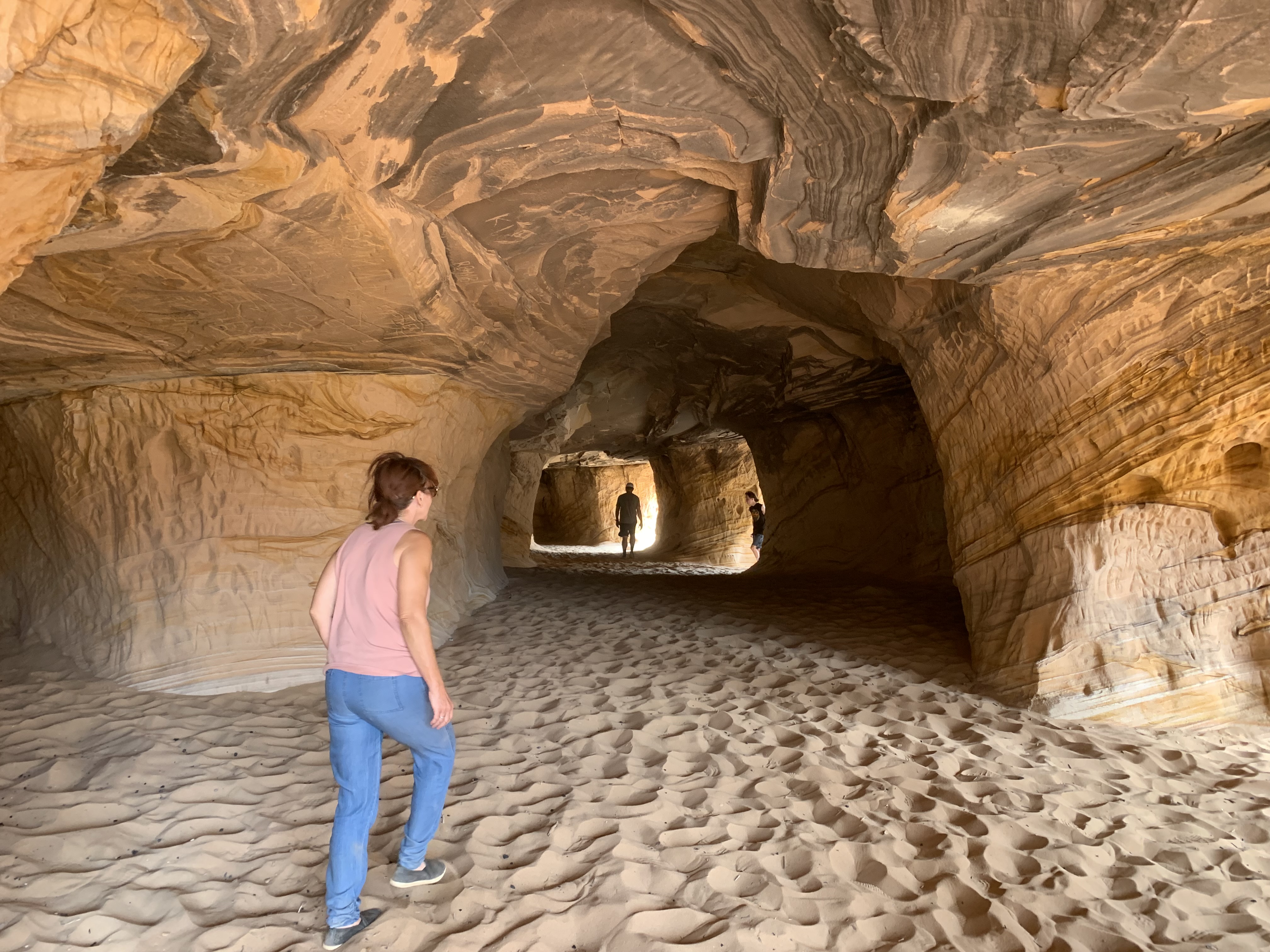 | 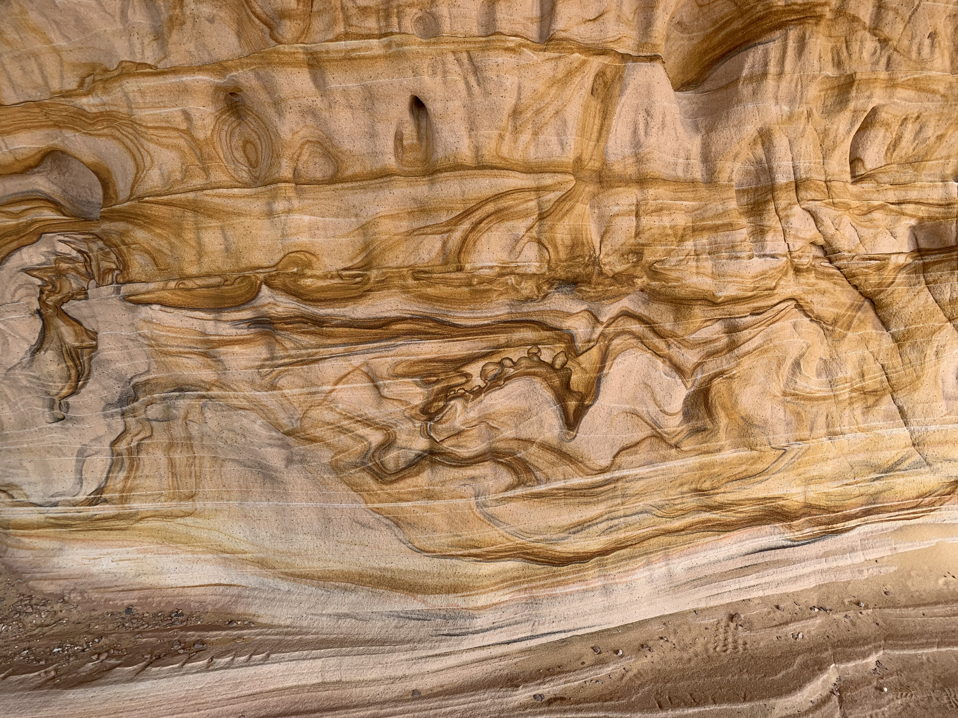 |
Tourist Alert: Kanab is in a dry county. If you plan on purchasing any adult beverages, head south on US-89A a couple of miles and back into Arizona. There's a place on the left right after the state line.
Relive 'Inchworm Arch with Robyn, Shari & Murph'

The Coral Pink Sand Dunes are about thirty minutes from Kanab. Head north on 89 for 5-6 miles (8-10km) and then look for signs pointing to the left. There are a couple of ways to get to the entrance to the dunes and to the camp ground.
The campground is nice and neat and you can get your self tucked into the trees in some of the spots. The park is has a lot to pull in, park and wander about. There is an entry fee.
If you have a UTV or Jeep (or have rented one), you can go play in the dunes. We got lucky and had a nice rain storm that wiped the dunes clean and gave us a lot of traction. If the sand is dry, air your tires down to 5psi (UTV) or 10 (Jeep) and it'll help you from getting stuck. There's a lot of areas to go play in.
There are also a large number of US Forestry trails in the area. We did a lot of off roading and exploring while we were there.
Tourist Alert: Wear shoes if the temps are up. Sand gets REALLY HOT and even I can't wander in the stuff barefoot and I have caveman feet.
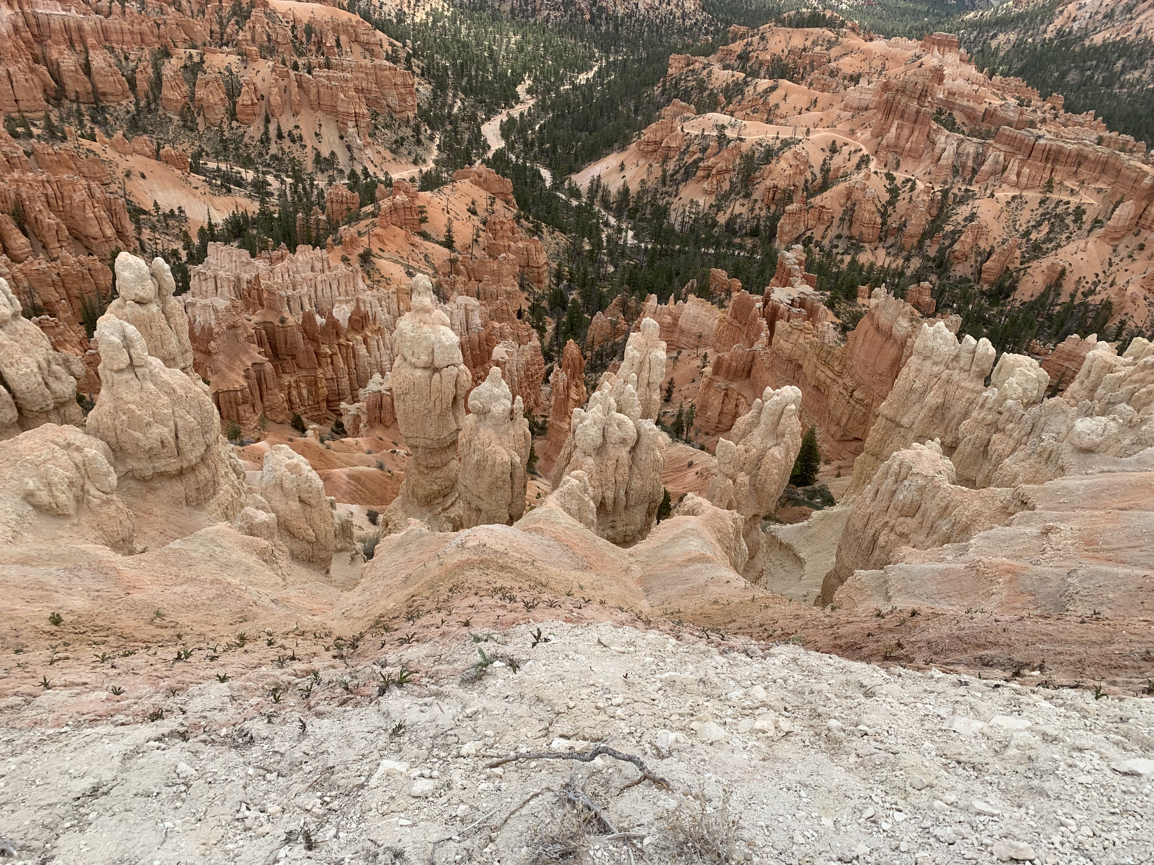
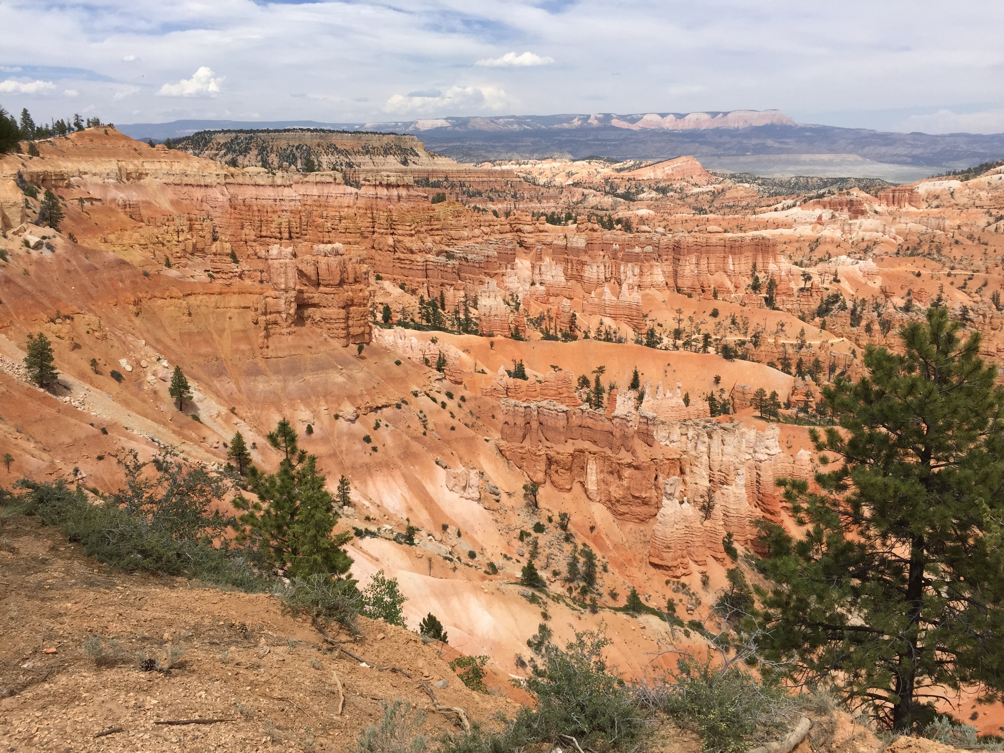
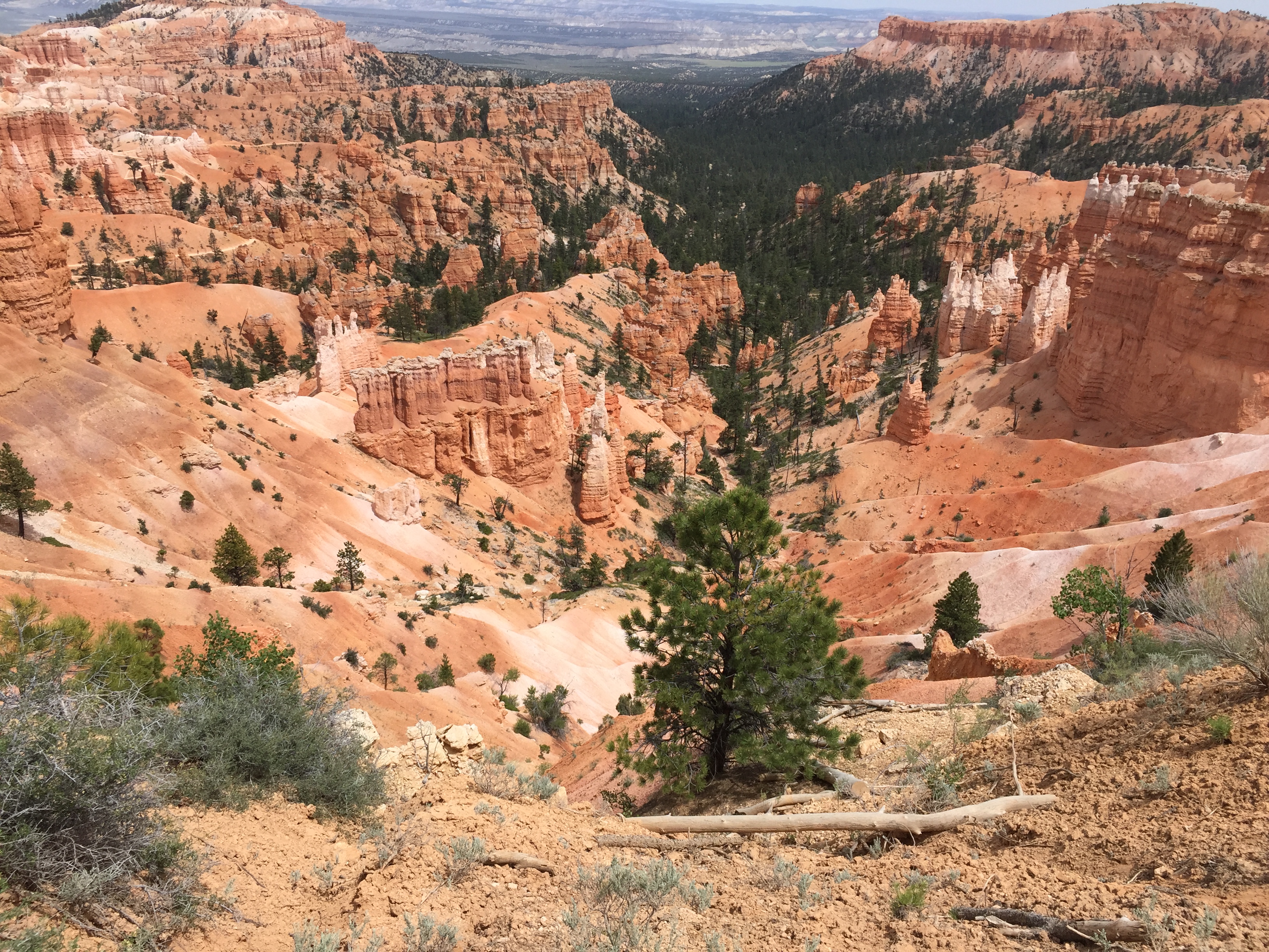
Bryce needs to be on everyone's bucket list. It's nowhere near as large as the Grand Canyon but it's so much prettier. The rock formations are spectacular and you can hike down into them if you're up to it. There are a few ways to get to Bryce. I advise that you follow your GPS guidance. (Use Waze - it rocks!)
Tourist Alert: Watch out for the tourists that arrive en mass via the tour busses out of California. They have no courtesy nor any regard for personal space.
 |
 |
 |
 |
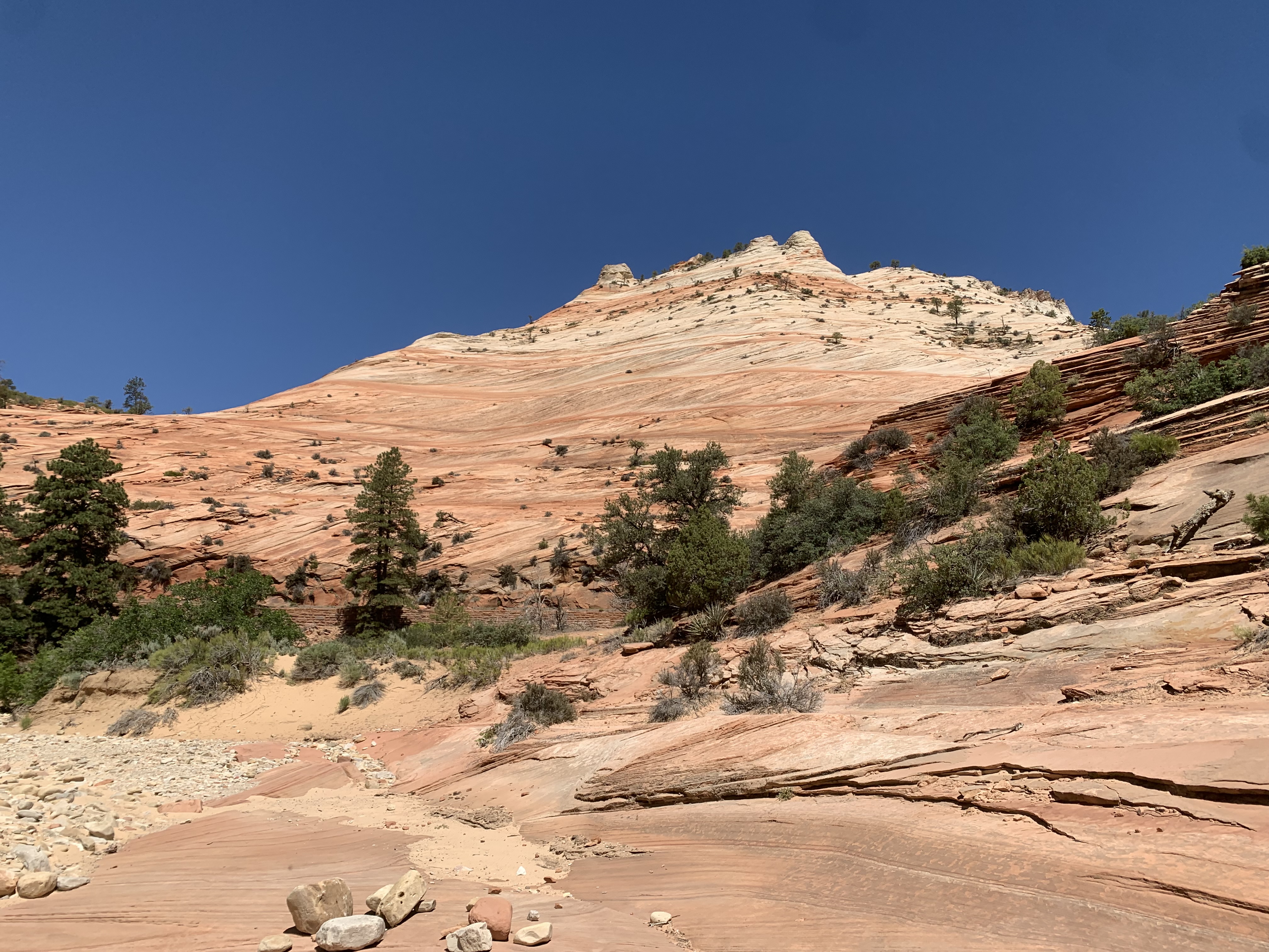
Zion is another place that everyone should experience. You can stay on either end of it and then drive through the park. Every turn gives way to another spectacular view of the terrain and surroundings. Play tourist there, it's worth it.
We stayed in Springdale and then drove to the park with our bikes. There are restaurants all along Zion Park Blvd, which follows the Virgin River.
Tourist Alert: Take a bicycle and see it that way. You'll get a more intimate experience. When we were there last, only bicycles and the tour busses were allowed in certain areas so we didn't have to deal with the crowds much at all.
 |  |  |  |
Relive 'Zion Bike ride. Whew!'
Las Vegas is about 300 miles (485km) and four and a half to five hours from the R&R. It's an easy drive. Head west on Carefree Highway (AZ-74) to Wickenburg, turn north, find US-93, follow that to I-40, turn west and go to Kingman. Stay on US-93 and you'll end up in Vegas. Stop and see the Hoover Dam while you're near it. Well worth the venture into the structure or just to walk along the top of it looking down to the Colorado.
Vegas offers EVERYTHING. You can stay on the south end of the strip down by the Belagio and watch the fountains or you can go up to the old section along Fremont Street and watch the people. I actually find the people watching more fun up on Fremont.
Take in a show - there are all sorts of them, all over the strip and around it too. We go up a couple of times a year to have a nice dinner and show and then come back the following day. There's so much to do that I'll let anyone reading this do their own research.
Tourist Alert: It's Vegas! It IS a tourist alert! ENJOY! Oh, one last word of advice regarding Vegas: Don't get married there. It's not cool, it's cheesy. Been there, done that, it was bad... Bachelor/bachelorette party? Sure! Live it up, but save getting married for some place that's special, not Las Vegas.
I hope you've enjoyed this Tourist Guide and that it gives you some ideas of where to go and what to see. My wife Robyn and I have truly enjoyed the decade that we've lived here exploring this unique state, State 48, Arizona
If you have the want to contact me, hit the Return Home link below, head to the bottom of the home page and there's an e-mail link. I'd be happy to answer questions and such. I'll also be adding to this page as we travel.
Get out there and see the world! It's an incredible place.